Meteorological Spring may be well underway, but the winter storm/gale track remains active over the North Atlantic.
Last week a strong low pressure system over the Central Atlantic, with a building high pressure ridge to its southwest and a stronger high pressure system over the UK to its east, yielded conditions approaching hurricane strength west and southwest of the storm center. These conditions persisted between the 17th and 19th of March, with peak conditions noted on the 18th (see Figure 1).
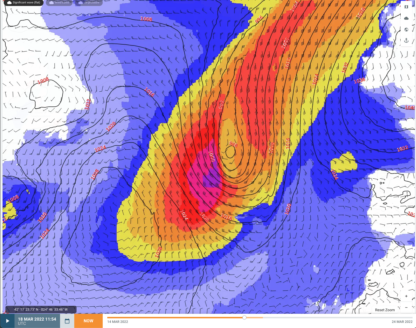
Fig. 1: Wind and Significant Wave Heights (SWH) of North Atlantic System from the GFS model at 18 March 12z.
As this system moved to the northeast, the associated swells propagated E’ward, impacting the Northeast Atlantic on the 19th, subsiding by the evening of the 20th. A more in depth discussion can be seen in our associated Fleetweather Connection video.
A second storm that was located south of Nova Scotia reached its lowest pressure of 965mb near 48N/37W by 20/06z. Thereafter, the track shifted towards the southeast, and the system will gradually fill and weaken as it approaches Iberian Peninsula by the 23rd. This system’s eventual track is being blocked by the strong high pressure ridge across the UK and much of central Europe mentioned above.
As we all know, we have to adjust to Mother Nature, and no matter the size and build, vessels are not immune to these types of heavy weather conditions. This article’s vessel of interest, a Suezmax Tanker of 46m beam and DWT of 149999mt, is underway from Corpus Christi. Their original route was a straight rhumbline from the English Channel to Northeast Providence Channel (shown in green in fig. 2). As can be seen in Figure 2, this would have exposed this particular vessel’s beam to a period of long-period, high seas, with significant wave heights (SWH) in excess of 7 meters, along with prolonged gale force winds and a brief period of storm winds.
A common alternative route is more south near/between the Azores Islands. This option provides shelter from these otherwise unavoidable conditions, via location from the storms and also much reduced fetch in lee of the islands. Our newly recommended route (shown in pink in fig. 2) suggested for the Master to alter vessel course to between the Azores before resuming course for Northeast Providence Channel. Taking our new route, the vessel experienced 2 meter less SWH’s along with Strong to Near Gale winds instead.
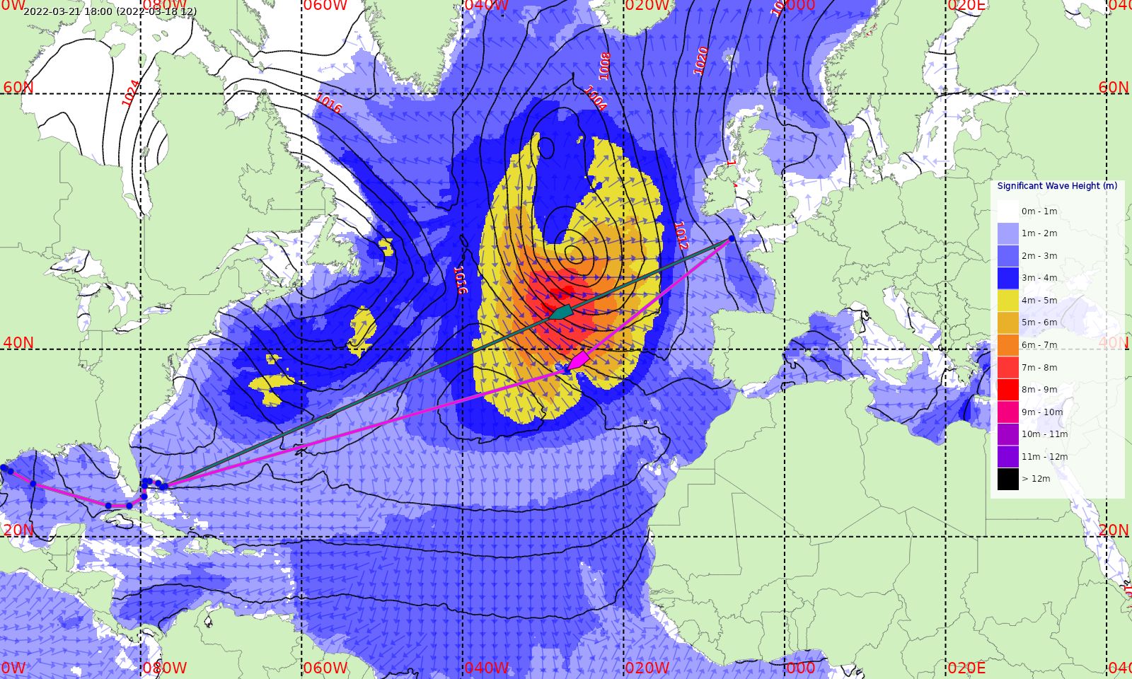
Fig. 2: Comparison of original route (Green) and new Recommended Route (Pink) at 21 March 1800Z using the 18 March 12Z run of the GFS model. Significant wave height and direction shown.
Putting the numbers into this scenario, while our new recommended route added 180nm compared to the previous route, we must take into account the expected impacts of weather and currents throughout the voyage. After taking these factors into account, the distance through water comes down to only 21nm more, and a mere difference of 1.5hrs between routes. While this may seem like an insignificant difference, knowing of the weather conditions that this vessel will be avoiding after such an increase of distance really puts this all into perspective, as the remaining weather factor of -0.8 improves to a relatively more reasonable -0.45 on the new route. Further, smaller course adjustments on the northern route in order to better handle the significantly heavier swell could have easily made the northern route longer or at least similar in regard to timing. Increased slip and consumption during these heavy weather adjustments could have easily tipped the scales toward a higher overall consumption and emission.
Be sure to follow Fleetweather on Linkedin to keep abreast of the latest weather conditions going on throughout the world via our Fleetweather Connection videos.
Stay connected and safe.