Hurricane season in the North Atlantic does not begin until June 1st, but a named storm may develop prior to the start of the season for the 7th straight year in a row. An area of low pressure is developing about 700nm east of Bermuda. This low (designated Invest 90L by NHC) is expected to move generally to the north on the 20th May while strengthening into a non-tropical gale. It is then expected to turn southwestward on 21st, and will likely begin to acquire subtropical characteristics. As of 0600z on May 20th, the NHC was giving this system a 50% chance of becoming a subtropical cyclone within 48 hours, and an 80% chance within 120 hours. Below details how this system may develop. If so, then the first name on the 2021 list is Ana.
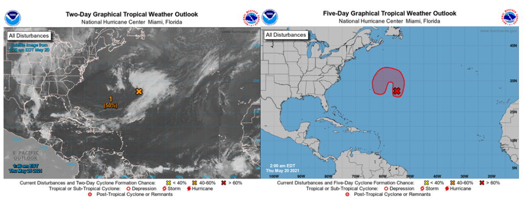
Two-(Left) and Five-Day (Righ) Tropical Weather Outlook for Invest 90L from 0600z on May 20th (Image credit: National Hurricane Centre, NHC)
There is very good agreement by the models on the evolution of this system. The image below shows the GFS model upper-tropospheric analysis for 06Z 20 May showing a deep trough in the jet stream over the western Atlantic, with an upper-level low forming in the base of the trough. Downstream of the trough, the new surface low is developing near the entrance region of the jet streak.
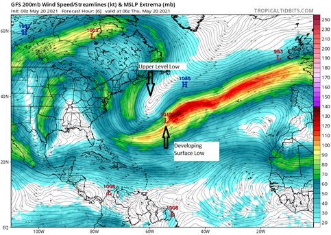
00z May 20 GFS depiction of 200mb winds, valid 06z May 20th. Surface highs and lows are also labelled. (Image credit: Tropical Tidbits)
The upper-level low is expected to move slowly to the southwest towards Bermuda and become cut-off. Meanwhile, the surface low will strengthen into a gale as it moves counterclockwise around the upper-level low and become co-located with the upper-level low on 21st as shown in next image below. At this point, the system will likely become a subtropical cyclone and remain quasi-stationary through the weekend, before swinging and moving away to the northeast and weaken.
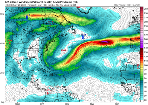
00z May 20 GFS depiction of 200mb winds, valid 18z May 21st. Surface highs and lows are also labelled. (Image credit: Tropical Tidbits)
Subtropical cyclones are “hybrid” systems that have characteristics of both tropical cyclones and extratropical cyclones. In the case of Invest 90L, its likely transition into a subtropical cyclone will be for two key reasons. The first reason is increasing sea surface temperatures (SSTs) as it moves to the southwest from 17-20 Deg C to 20-23 Deg C over the period 21-24 May. These warmer SSTs will allow for increased convection near the centre of circulation, aiding the transition into a subtropical system.
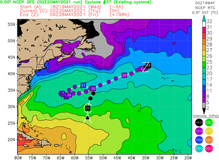
May 20th 00z GFS forecast of the track and intensity of Invest 90L, overlaid over SSTs (image credit: Florida State University, FSU)
However, the SSTs along the forecasted track are expected to remain below 26C, the typical threshold for tropical cyclone formation. So these warming waters alone will not be enough. This is where the upper-level low comes into play, as it creates an area of colder than normal upper-tropospheric temperatures. The contrast between the warming waters and colder upper-levels increases instability, allowing convection to become more vigorous and organized. This reliance on the upper-level low is a key reason why the system will likely become a subtropical cyclone as opposed to a tropical cyclone.
Given its proximity to major cross Atlantic shipping routes Invest 90L will have a potentially disruptive impact on shipping. Both during its extratropical and subtropical phases, the system will likely create areas of gale to potentially storm force winds and very rough to potentially high (7-8M) seas for a time.
Stay Connected and Safe!