As the 2022 Hurricane Season began it started off with an interesting case of Hurricane Agatha which developed in the eastern Pacific Ocean. Agatha intensified and then made landfall just West of the Gulf of Tehuantepec, before dissipating over Mexico. The remnants of the system were one of the ingredients that helped spin up Tropical Storm Alex in the Atlantic Ocean.
This has raised the question: Is it rare for a tropical cyclone to cross over from the Pacific Ocean to the Atlantic Ocean and vice versa? The best answer is yes and no. Yes, it is rare for classified tropical cyclones to cross ocean basins while maintaining their structure. This is because once a tropical cyclone makes landfall, normally, it quickly dissipates as it is disconnected from its main source of moisture, may move into an area of high shear, and/or interact with terrain which further deteriorates the structure.
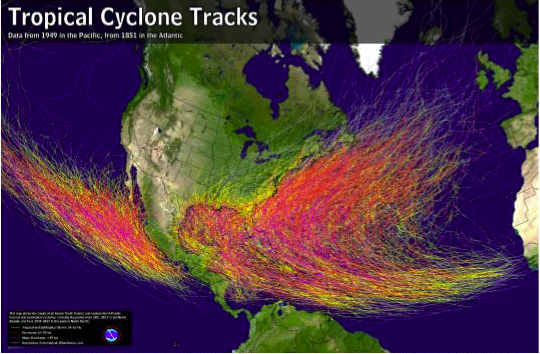
However, it is more common for developed tropical cyclones to degenerate once they are over land and have their remnants re-generate in another basin under the right conditions. When this does occur, records show it is more common for tropical cyclones to move from the Atlantic Ocean to the Pacific Ocean, which is not surprising because upper air flow, primarily responsible for steering cyclones, is generally from east to west in the tropics.
Before the 2000 hurricane season, even if a tropical cyclone did not dissipate, when a tropical cyclone moved from the Pacific basin to the Atlantic basin, and vice versa, it was renamed. After 2000, the World Meteorological Organization (WMO) decided to change the name of a tropical cyclone that transfers basins only if it dissipates before moving into another basin, otherwise the name would stay the same. Since 1851, there have only been 18 tropical cyclones that have crossed basins and maintained their structure.
Since 2000, after the WMO updated the rule, Hurricane Otto (2016) is the only tropical cyclone to cross basins and maintain their name.
Hurricane Otto
Otto developed late in the 2016 hurricane season in the southwestern Caribbean, and was upgraded to a Hurricane peaking at 100kt (115mph) intensity. Otto maintained this intensity, making landfall as a category 3 hurricane near the Nicaragua and Costa Rica border. Otto was able to maintain its structure and status as a hurricane after making landfall, thus the name was able to carry over into the Pacific basin, but rapidly weakened thereafter. It was downgraded to a tropical storm before re-emerging in the Pacific by 25 November, then continued weakening until dissipation 33 hours later. Otto was the strongest hurricane (on record) that developed that late in the year, making it the latest land-falling hurricane in the Atlantic basin.
A large part in why Otto was able to keep its name once it crossed basins was due to where it made landfall. Otto made landfall near the border of Costa Rica and Nicaragua, which is devoid of a chain of mountains; the highest elevation in that area is about 1000m. In contrast, Agatha made landfall along the Sierra Madre del Sur and Alma made landfall along mountainous terrain in Nicaragua which ultimately led to its demise. See more on Agatha and Alma below.

2022 Hurricane Agatha/Alex Case
Compared to Hurricane Otto, what is more typically seen is the tropical cyclone dissipating over land and the remnant low regenerating or being an ingredient in the regeneration in the new ocean basin. As was the case here with the first tropical cyclone for the 2022 hurricane season. It started in the Eastern Pacific with Tropical Depression One-E which developed on 28 May and eventually made landfall as a Category 2 hurricane just west of Puerto Angel on the afternoon of 30 May, making it the strongest hurricane to make landfall along the Pacific coast of Mexico in May.
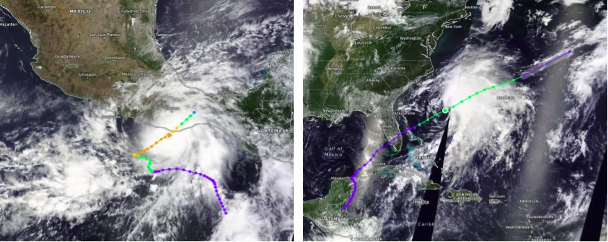
Shortly after making landfall Agatha quickly weakened and the surface low dissipated, losing its name in the process. However, due to the presence of the mid-level circulation being absorbed by a pre-existing surface low in the Caribbean Sea, along with other favorable environmental conditions, Potential Tropical Cyclone (PTC) One, which was later named Tropical Storm Alex, was able to develop by 02 June. PTC One had most of the conditions needed for development but high wind shear prevented it from organizing. This resulted in PTC One producing disheveled convection across the Caribbean Sea for 61hrs before being upgraded to Tropical Storm Alex by 0500 UTC 5 June, after crossing over Southern Florida. Alex continued to track NE peaking at 60kt (69mph) by 0300 UTC 6 June. By 2100 UTC 6 June, Alex was devoid of convection and classified as a post-tropical cyclone, later developing frontal boundaries. While Agatha and Alex are interesting cases, there are multiple examples of tropical cyclones in the past that have dissipated over land and regenerated either in the E. Pacific or W. Atlantic.
2008 Tropical Storms Alma and Arthur
A similar situation occurred around the same point in the hurricane season, in late May/early June 2008 with the first named systems of the 2008 hurricane season, Tropical Storm Alma and Arthur. Alma developed from a stationary trough in the E. Pacific about 225n mi southwest of the Nicaraguan coast by 27 May 2008. By 0000 UTC 29 May 2008 it was upgraded to a tropical depression as it tracked Northward and 12 hours later it was further upgraded to Tropical Storm Alma, the first named storm for the 2008 season, peaking at 55 kt (63mph). Alma maintained this intensity, making landfall near Leon, Nicaragua by 1945 UTC 29 May 2008, breaking several records in the process. It was the first tropical system (since available records in 1949) to make landfall along the Pacific coast of Central America, which made it also the first system to make landfall along the Pacific coast of Nicaragua, and the furthest east a tropical system made landfall in the E. Pacific. As expected, soon after landfall Alma weakened to a remnant low by 1800 UTC 30 May 2008.
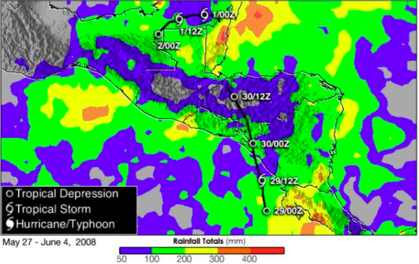
As Alma’s remnants moved across Central America, the surface low pressure dissipated over the mountains in Honduras, however the mid-level circulation was able to survive and redevelop in the Atlantic basin, near Belize, as the circulation moved over a tropical wave and developed into a surface low. Much like Alex, Arthur had a short life becoming a tropical storm by 0000 UTC May 31, 2008, not long after the new surface low developed. Arthur tracked WNW, peaking at 40 kt (46mph), just six hours after being named and dissipated over Belize by 0600 UTC 2 June 2008.
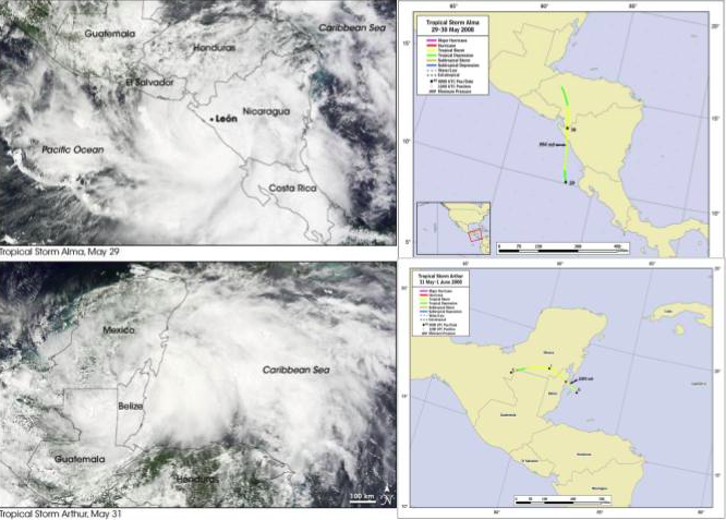
Bottom: Satellite image of Tropical Storm Arthur 31 May 2008 with official track to the right. (Source: Satellite images from Goddard Land Processes Data Archive and official track from National Hurricane Center)
With the 2022 hurricane season starting with such an interesting case, it will be fascinating to see how the rest of the season will play out.
Stay Connected and Safe.
Sources
Blake, E. (2008). Tropical Cyclone Report: Tropical Storm Arthur 31 May – 1 June 2008. National Hurricane Center
Brown, D. (2008). Tropical Cyclone Report: Tropical Storm Alma 29-30 May 2008. National Hurricane Center.
Gutro, R. (2008, May 29). NASA – Hurricane Season 2008: Tropical Storm Alma (Eastern Pacific Ocean). NASA – Hurricane Season 2008: Tropical Storm Alma (Eastern Pacific Ocean); www.nasa.gov.
Bob Henson, M. by, & Jeff Masters, M. by. (2022, June 5). After South Florida deluge, Tropical Storm Alex finally develops » Yale Climate Connections. Yale Climate Connections; yaleclimateconnections.org.
Masters, J. (2022, June 1). Hurricane Agatha leaves 11 dead, 32 missing in Mexico; remnants reorganizing in Caribbean ” yale climate connections. Yale Climate Connections. yaleclimateconnections.org.