Among the many weather events anticipated as the northern hemisphere starts to move in to Winter, the developing Northeast (NE) Monsoon regime is one event that we keep a close eye on. For this blog, we will dive into how this monsoon regime forms and talk about how the incoming surge of north-easterly (NE’ly) winds, specifically in the South China Sea, affects shipping.
Figure 1. General Synoptic Pattern for the Northeast Monsoon (Courtesy of UCAR COMET)
So what takes place for the NE monsoon to begin? Figure 1 shows, as winter approaches, a strong surface high over Siberia begins to build and intensify due to radiative cooling and cold air advection from the Arctic. At the same time low pressure forms over Australasia with the southern hemisphere summer solstice in December. In addition, the polar and subtropical jetstreams join together off China which promotes cyclogenesis and deepens any low pressure systems moving east over the Yellow Sea. These lows then increase the pressure gradient with the high over Siberia and so intensify the NE’ly flow over the East China Sea and South China Sea (SCS) providing a cold surge that can extend from the Sea of Japan to the SCS.
Figure 2. 07/12z Nov 21 GFS Run of 250mb Wind Speeds valid for 07/12z Nov 21, Courtesy of Weatherbell)
A good example of this intensification occurred over the last few days. As seen in Figure 2, the strong subtropical jet over China interacted with the polar jet digging south over the Bohai Sea 7-8th Nov. This interaction along with the strong jet streak downstream of the polar jet trough promoted cyclogenesis and helped intensify the low pressure over Russia/N Korea as shown in Figure 3.
Figure 3: 06/12z GFS run showing Surface winds at 08/00z
At the same time, strong ridging associated with a high over Siberia extended east over the East China Sea by 08/00z with the tight pressure gradient between the low and high pressure being advected SW over the SCS 8-9th Nov. These winds can strengthen to near gales at times or even gale force when enhanced locally by funnelling within the Luzon and Taiwan Straits. Longer range guidance shows the strong to near gale NE’ly winds continuing into the end of next week as the strong ridging remains in place across the region, helped by the continuous development of low pressure systems along the active North Pacific gale/storm track.
As we progress into winter, the NE Monsoon regime generally strengthens and reaches its peak around January where strong to gale conditions can spread across much of the region. As part of this the NE monsoon winds fluctuate and are strongest when high pressure over Asia/Siberia extends a ridge E towards Japan, so periodically strengthening the gradient.
Optimised Routing
The NE Monsoon regime impacts the major shipping lanes for vessels transiting to and from East Asia. These enhanced conditions delay the arrival times of northbound vessels as strong headwinds, rough seas and currents all have a negative impact on a vessel’s performance. Outside of any typhoon being present, there is generally little choice in terms of optimising routes in the SCS during either monsoon season in terms of comparable distance efficient or near efficient scenarios. As such, the routes tend to persist as shortest (most direct) and safest.
Figure 5. Pre-voyage brief showing standard shortest route (pink) and optimal route (green) via Palawan Passage
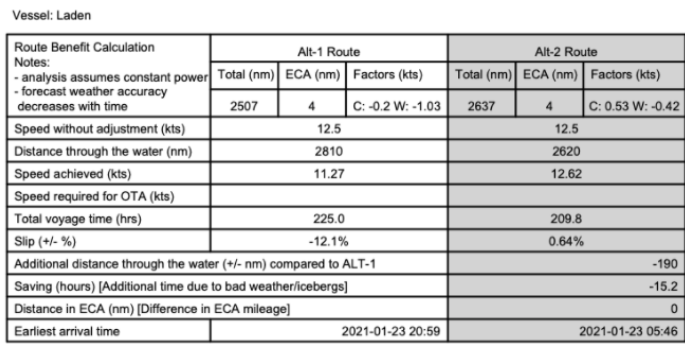
However, one option in the NE Monsoon season is to route more inshore and exploit the shelter of the Palawan Passage which can save distance, time and fuel compared to a more direct shorter route across more exposed SCS conditions. An example is shown at Figure 5 for a vessel routing from Singapore to Ulsan earlier this year in Jan 2021. The pre- voyage table summary for this is shown below in Table 1 which assumes a constant RPM (set for 12.5kt) for the vessel where wind and current factors will fluctuate the actual speed achieved.

Table 1. Pre Voyage Brief from Singapore to Ulsan dated January 2021
The most direct route (labelled Alt-1 in pink) was 2507nm over the ground but 2810nm distance through the water after weather and current factors. The optimized route (Alt-2, Green Route) via the Palawan Passage was 2637nm and 2620nm respectively; a saving of 190 nm or 15.2hrs sailing time resulting in an earlier ETA of Jan 23/0546z compared to Jan 23/2059z.
Summary
In conclusion, the NE Monsoon has made its grand entrance across the South China Sea on cue. While the optimal route is generally the shortest route in the SCS this is not always the case, and depending on conditions at the time the Palawan Passage may offer a viable alternate route for northbound vessels. Fleetweather will always be closely monitoring the conditions, in addition to providing safe and efficient routing for another winter season across this region and the Northwest Pacific in general.
Stay safe and stay connected