Officially classified by the Brazilian Navy Hydrographic Centre, Subtropical Storm Potira formed on April 20th off the coast of Brazil. The system remained relatively weak, with maximum sustained winds peaking between 45-50kts, mainly to the south of the centre on 21st and 22nd before it moved southeast and dissipated.
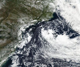
Subtropical Storm Potira off the coast of SE Brazil on Tuesday, April 21, 2021. (NASA/WorldView)
When hearing the term “subtropical”, this refers to a non-frontal low pressure system that has both tropical and extratropical characteristics. Extratropical cyclones have cold air at their core, and derive their energy from the release of potential energy when cold and warm air masses interact, such as low pressure systems at mid-latitudes.
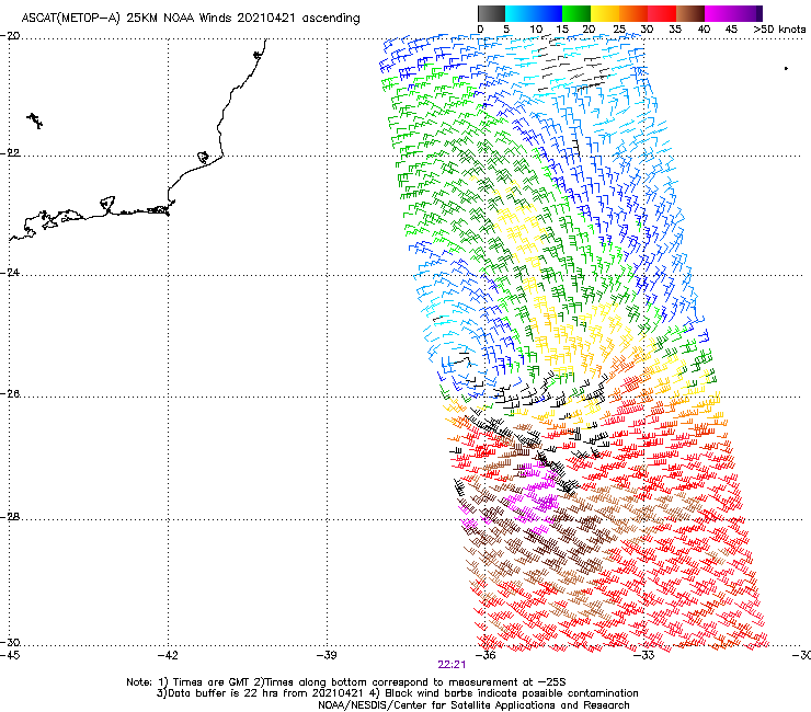
NOAA/NESDIS/Center for Satellite Applications and Research: ASCAT (Metop-A) winds 201210421 ascending showing 45-50Kt winds (purple-black wind barbs).
If the waters under the extra-tropical cyclone are sufficiently warm enough (generally above 20C), thunderstorm activity may increase/build near the centre, releasing latent heat and allowing the surrounding environment near the centre to begin warming. If the sustained winds are at least 34kts, then the storm can be classified as a subtropical storm. However, if the thunderstorm activity continues to grow near the centre, the system may become fully warm at the core and so transition to be fully tropical, especially if sea surface temperatures are as high as 25-26 Deg C.
Generally, a subtropical storm will typically have a broad area of maximum winds that are located further from the centre. The wind field and areas of associated thunderstorms tend to be unevenly distributed around the system. This differs from fully developed tropical systems, where the wind field and thunderstorm activity are more evenly distributed and concentrated near the centre.
Potira fitted this profile; it started as a non-tropical disturbance that moved off the coast of Brazil and stalled over the warm Brazil current offshore where it gradually started to become more organised and take on some characteristics of a tropical storm.
So what is the frequency of Subtropical Storms in the South Atlantic?
Each year, more than a dozen named tropical and/or subtropical storms form in the North Atlantic and Caribbean. So what about the South Atlantic?
The frequency is much less, with fully developed tropical systems considered “rare”. There have only been 14 named tropical systems in the southern Atlantic Ocean since 1991, most of which were subtropical storms. The only hurricane was Hurricane Catarina in 2004, which reached Cat 2 (Saffir-Simpson scale), and there have only been two Tropical Storms Anita (2010) and Iba (2019) recorded over the last 20 years. Why such a rarity?
For Starters, South Atlantic sea surface temperatures are relatively cooler, generally less than 26C, which is needed to allow, develop and sustain full tropical systems. Also, there is a good amount of persistent wind shear (changing wind speeds or directions with height), which acts to inhibit tropical cyclone development.
While still not as common in the North Atlantic, subtropical cyclones do occur more frequently than one might expect, typically about once a year. However, following Hurricane Caterina in 2004, forecasters and researchers began to pay more attention to the South Atlantic and research in 2012 (Climatology of Subtropical Cyclones in S. Atlantic) revealed that 63 subtropical cyclones had formed between 1957 and 2007, mostly off the coast of Brazil.
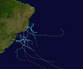
Tracks of South Atlantic tropical and subtropical cyclones since 2004 (NASA)
If the right environmental ingredients are present, as areas of low pressure move across the Andes Mountains and/or the Brazil Highlands, further cyclonic spin can develop once downwind of the mountain range, aiding in low pressure development. These areas of low pressure then move off the coast and over the warm Brazil current and so can develop further.
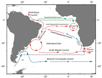
South Atlantic schematic of major current systems from IGMETS Project. Red arrows indicate warmer currents; blue arrows cooler water currents
Years with anomalously warm Sea Surface temperatures may increase frequency. This is a similar setup to that off the east coast of the United States and the Gulf Stream. The study showed that during the time period from 1957-2007 there is an average of about one subtropical cyclone per year.
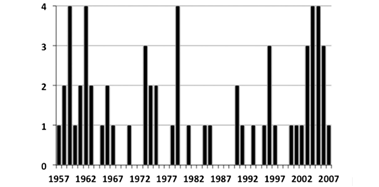
Annual Frequencies of Subtropical Cytclones genesis in the South Atlantic basin 1957-2007 (Citation: Journal of Climate 25, 21; 10.1175/JCLI-D-11-00212.1)
More interesting, is that in comparing this region to the North Atlantic, the frequency is more uniform throughout the year in the South Atlantic, with some peaks near the Equinoxes. As such, monitoring for the formation and occurrence of these systems in the South Atlantic is an all year round rather than seasonal requirement.
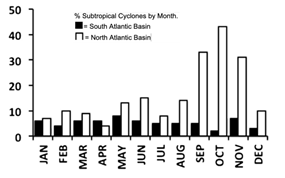
Monthly distribution of Subtropical Cyclones in the South Atlantic (Black; 63) and the North Atlantic (White; 197) (Citation: Journal of Climate 25, 21; 10.1175/JCLI-D-11-00212.1)
Stay connected and safe.