Masters often receive competing weather routing advice due to shipowners, charterers and ship operators using their own weather service provider. While savings in time, cost, fuel, and emissions are key to optimal routing safety always takes precedence. This case example highlights some of the dilemmas that can arise.
Background
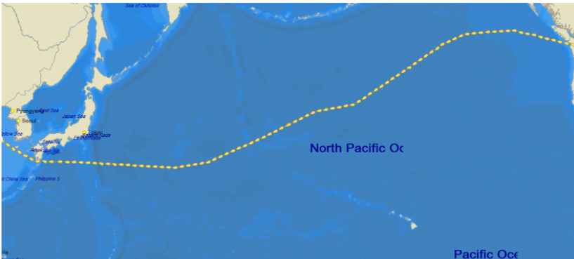
In early December a 33,000 DWT Bulker Master reported receiving two very different route recommendations as shown in Figure 1. The Charterer’s weather routing was for a great circle (GC) route via the Bering Sea (magenta). A statement was made by them to the Master on 03 Dec, of “Increasing conditions, up to BF 7 and 5m significant waves, are expected along the route as you approach Unimak Passage…” (more on this later). While we agree that route would have saved at least a day of steaming, it was deemed as more risky by Fleetweather and potentially ultimately as unsafe by the Master when looking at all available sources, including established weather patterns and specialist marine forecaster knowledge. Our initial recommendation (green) was for a GC to 49N/150W, then a Rhumb line to 43N/170E then to abeam Cape Erimo-Misaki then direct-Qingdao via Tsugaru Kaikyo. This routing also offered the flexibility to deviate further south if need be which, for the right reasons, is what happened and is explained below.

Figure 1. Route Comparison of Fleetweather (green) vs Charterer’s (magenta) showing typical currents from NCEP HYCOM.
Optimization Analysis
The expected wind/wave and currents effects for each route shown in Figure 1( from the sea position exiting the ECA off North America to the Qingdao pilot station) are shown in Table 1 below, which assumes constant power (rpm) for 12 knots.
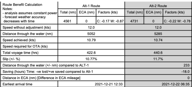
Table 1. Route Comparison Alt-1 (via Bering Sea) and Alt-2 (Fleetweather initial recommendation)
One can see that the vessel would have arrived 18 hours later using our recommended route, based on both model and climatology data. While the weather factor is high for both routes the difference is still significant. The issue here lies with the risk of vessels encountering certain conditions enroute, where expected or likely potential peak conditions must be considered for safety.
Routing Considerations
On occasion, the opposite can be true where benign weather can dominate the first week or so of the forecast, allowing for greater confidence in a more aggressive higher latitude route being viable. In this scenario, as a “backup” option (should longer range weather beyond the reasonable scope of accuracy change for the worse), there is plenty of advance time and sea room in benign weather in which to make good speed toward a large course alteration. So, “not all is lost” in this scenario, and the route remains safe.
Situation Analysis
However, the route scenario for this vessel/voyage did not fall into either of the above categories. Multiple periods of heavy weather were expected for much of the first week of the voyage for the northerly route, pushing (arguably exceeding) the threshold of acceptability for a Bulker this size. What this means is that had longer-range conditions (as the vessel passed by the Aleutian Islands and further westward) deteriorated to even worse than was expected as medium range forecast data came into better purview, alterations for avoidance would have been “tricky at best” within already heavy weather.
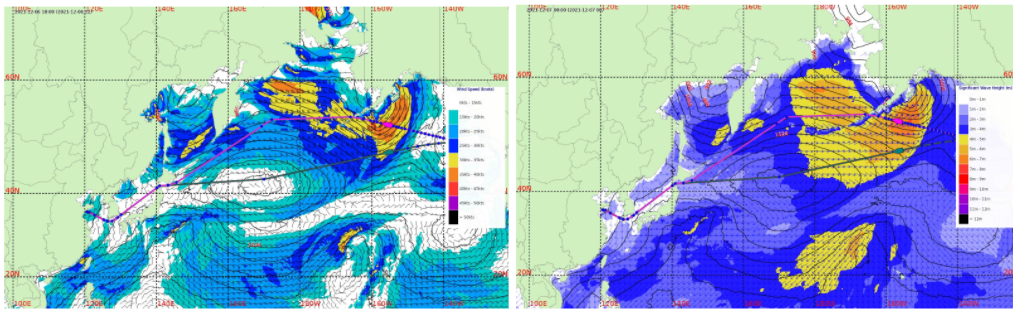
Figure 2. Wind analysis for (Left) 06 Dec 18:00 UTC and (Right) Wave analysis for 07 Dec 00:00 UTC. Source NOAA GFS and HYCOM
Figure 2 shows that the vessel would have passed through more than 40 Kt winds and 6-7m significant wave heights (SWH) on the northerly route which were unavoidable if approaching the Unimak Pass, which at times build to 7-8m in the Bering Sea as shown in Figure 3. Our more southerly route was agreed by the Master as it also allowed one to deviate even further south later on if need be.
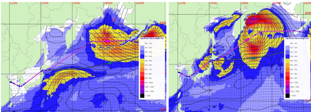
Figure 3. Significant Wave Height (m) (Left) 10 Dec 06:00 UTC and (Right) 13 Dec 00:00 UTC
Significant Wave Height (SWH)
Figure 3 also shows that heavy weather was expected in the longer range (near/after 13 Dec) on both routes, thus validating the southerly route which would allow the option to reroute further south to south of 40N latitude and pass via south of Japan to avoid all of this. Figure 4 shows the eventual route taken accordingly.
Masters and seasoned routers know there is less opportunity to avoid future heavy weather when already in heavy weather. Alterations to route/speed create greater uncertainty in subsequent expected vessel location. This expected unpredictability in track creates, in turn, a greater chance of exposure to further heavy weather in the longer range.
Summary
This case is a good example of where experienced human router knowledge working with a Master’s concerns can make a large difference and add value by allowing the consideration of a range of possibilities beyond what just raw model data provides.
By agreeing to Fleetweather’s recommended more southern route, the vessel avoided the heaviest weather approaching the Unimak Pass and in the Bering Sea, whilst allowing for deviation further south to avoid likely further heavy weather should this occur. At the time of our recommendation to alter the route to the south of Japan we provided an updated ETA of 22 Dec 08:13 UTC, and the vessel actually arrived at 22 Dec 08:00 UTC; only a few hours longer than our initial recommendation. However, periods of unavoidable 6-7m SWH on the Bering Sea route, followed by inevitable further adjustments enroute for heavy weather mitigation would have been significantly more difficult, causing further delays in addition to safety concerns.
Stay connected and safe.