The season for Tropical Storms in the Northern Pacific runs from 1st June to 30th November, similar to the North Atlantic Hurricane season. However, because the waters of the NW Pacific are essentially warm all year round, tropical storms can form at any time of the year in this region of the Pacific where they are called Typhoons.
Typhoon Surigae became the first typhoon of the 2021 season and intensified into a Super Typhoon 15th & 16th April to become the most intense Tropical Cyclone to form in the Northern Hemisphere before 1st May. Not to be outdone, Tropical Storm Andres formed on 9th May off SW Mexico to become the first named storm of the eastern Pacific region. It is also the earliest system to ever form during the satellite era ahead of the eastern Pacific hurricane season, which begins 15th May. There is also currently Tropical Depression (named as TC A by JMA, Tokyo and TD 03W by JTWC) which is currently over the Philippines and is expected to weaken and dissipate quickly over the next few days.
Since 2021 has got off to an early start in the northern Pacific it is worth having a look at what we can expect for the remainder of the year.
Background
Since the northern Pacific Ocean is so large the basin is divided into three different regions by the WMO. The Eastern Pacific basin is located E of 140 W and is monitored by the National Hurricane Centre in Miami. It is the second most active basin in the world and averages 15 named storms, 8 hurricanes and 4 major hurricanes per season. The Central Pacific basin is located between 140W and the International Date Line and is monitored by the Central Pacific Hurricane Centre in Honolulu. This region averages 4, 3 and 2 respectively. The North Western Pacific basin is located between the International Date Line and 100E, including the South China Sea, and is monitored by Japan Meteorological Agency in Tokyo, with coordination from other tropical cyclone warning centres in Guam (the Joint Typhoon Warning Centre), Philippines and Hong Kong. This is the most active tropical cyclone basin on Earth and accounts for almost ⅓ of the world’s annual tropical cyclones. On average there are 26 tropical storms, of which 16 reach typhoon strength and 8 become super typhoons (equivalent to hurricane Cat 3-5 strength).
In determining the outlook for the forthcoming season experts monitor a number of coupled ocean-atmosphere phenomenon: the El Nino-Southern Oscillation (ENSO), the Pacific Decadal Oscillation (PDO), the Atlantic Multi-Decadal Oscillation (AMO) and ACE, which is a metric that takes into account the tropical strength and life of the systems. There is also the Indian Ocean Dipole (IOD) which is important for the South China Sea.
ENSO
ENSO is the periodic fluctuation in sea surface temperature (SST) which has 3 different phases: El Nino, La Nina, and Neutral. The El Nino phase represents a major warming of the equatorial waters, while La Nina reflects a major cooling of the equatorial waters. ENSO-neutral occurs when there is no significant change and the sea surface temperature stays within -0.5C and +0.5C of the long-term average. Typically, El Nino years experience below average activity but greater intensity due to longer sea tracks while La Nina conditions shift the cyclogenesis region westward towards the Philippines reducing the sea track and so have above average activity with fewer intense typhoons. Cyclone paths tend to be westerly or northwesterly in El Nino years and to be more westerly and pass south of Taiwan under La Nina conditions. However, more recently ENSO-Modoki has been identified where warmer (cooler) SST occur in the central Pacific flanked by cool (warm) regions to both the east and west where El Nino Modoki (warmer) reflects above normal activity and vice versa for La Nina Modoki reflects (cooler) below normal activity). Research on using this to provide better seasonal forecasts remains ongoing for now.
What to expect from ENSO?
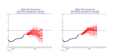
We have just entered an ENSO-neutral period afer a lengthy period of La Nina. The global model averages predicted a slow return to ENSO-neutral in May and to continue this into Winter 2021-22 with perhaps borderline La Nina conditions occurring late fall/early Winter.

Copernicus Climate Change Service (C3S): NCEP (Left) and ECWMF (Right) Nino 3.4 SST Anomaly Plume showing averaged-mean-sea-surface temperature anomalies of the tropical Pacific
PDO and AMO
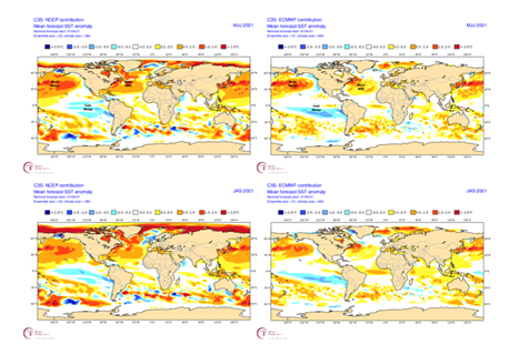
PDO is a long-term (20-30 years) ocean fluctuation of the Pacific Ocean between positive (warm) and negative (cold) phases. The positive (negative) phase is shown when the SST of the North Central Pacific are anomalously cold (warm) and the SST over the Eastern Pacific are anomalously warm (cold). The AMO tracks the same over the North Atlantic where the oscillation has a 20-40 year time span. So looking at the SST charts below one can see that both PDO and AMO are negative. AMO has been in the warm phase since 1990 and this is expected to continue through at-least the rest of the year.

Copernicus Climate Change Service (C3S): NCEP (Left) and ECWMF (Right) SST Anomaly for July-Sept 2021
ACE
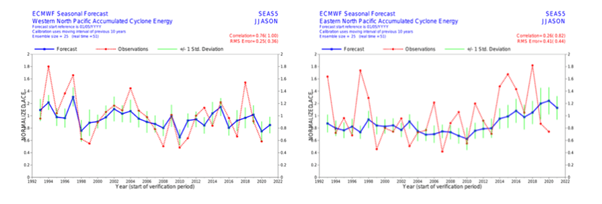
According to the ECMWF seasonal guidance ACE forecasts, the Northwest Pacific is expected to have a near normal or slightly below normal season. It is worth noting that the ECMWF has shown reasonable correlation when predicting normal or below normal seasons but tends to underestimate above normal seasons. As far as the Eastern North Pacific is concerned the ECMWF predicts a slightly above normal or near normal season in terms of ACE. It is of note that the model has either over predicted or under predicted the season since 2018, so it remains to see how they will do for 2021.

ECWMF 2021 season ACE forecast for NW Pacific (Left) and NE Pacific (Right)
IOD
The IOD is the Indian Ocean counterpart of the Pacific ENSO which also develops three phases. It is positive (negative) when the western IO is warmer (cooler) than the eastern IO or neutral when in between. It is currently neutral but is expected to become negative in the second half of the year. Generally above normal SSTs in the eastern IO result in a smaller temperature contrast across SE Asia and a weaker monsoon trough over the South China Sea with below average activity. Any cooling has the opposite effect with above average activity.
Summary
Northwest Pacific. The negative cool phase of the PDO should maintain the warm SSTs over the Western North Pacific Ocean and the expected neutral phase of ENSO should not create a limiting factor on the tropical cyclone development through at least July. However there is still the possibility of La Nina returning during the peak season which could cap the number of storms that form this year. Also given that the ECMWF is forecasting a near average ACE value, we could mostly expect a near or slightly below average Typhoon Season in the North Western Pacific.
Eastern and Central Pacific. The negative cool phase of PDO and warm phase of AMO are factors that could limit the development of the tropical systems over the region. However, ENSO is expected to remain in the neutral phase through at least the summer which should allow for systems to be able to transit further west into the central Pacific. Currently the ECMWF is forecasting slightly above average to average ACE values for the Eastern Pacific. All things considered, the Eastern Pacific should have a slightly above average or near average season and the Central Pacific should have a near or slightly below average season this year.
Clearly uncertainty exists on these forecasts which will likely not be resolved until later in the Summer, so stay tuned for updates.
Stay connected and safe.