With the northern hemisphere now well into winter it is also the time of year when Tehuantepecer wind events occur more frequently. So what is a Tehuantepecer event you may ask?
A Tehuantepecer (also called Tehuano Wind) is a post frontal N-NE’ly mountain gap wind that originates in the Bay of Campeche as cold high pressure moves south behind a cold front. As high pressure moves south from east of the Rockies towards the Sierra Madre Mountains, a strong pressure gradient forms across the Chivela Pass (a narrow mountain gap in the Sierra Madre, see above graphic from COMET illustrating location and topography), with the wind blowing south through the gap from higher towards lower pressure. The wind accelerates due to funnelling as it passes through the Chivela Pass and extends out over the Gulf of Tehuantepec. These winds can reach up to storm or hurricane force when there is a very strong pressure gradient, with gusts in excess of 100kts possible in extreme cases. As the fetch of the winds is rather short, significant wave heights typically only reach 5-7meters, so broadly speaking these events are more problematic for smaller vessels. The Tehuantepecer is most common during autumn and winter and can last up to 5-7 days, but it can occur at any time of the year.
These strong N-NE’ly winds in the Gulf of Tehuantepec usually extend about 100nm offshore, though lesser winds can extend a few hundred miles offshore into the Pacific. In addition, these winds generate wind waves with rough to high seas in the Gulf of Tehuantepec which extend up to a few hundred miles S-SSW offshore into the Pacific, with the residual swell reaching as far as the Galapagos Islands about 1000nm away.
Tehuantepecer wind events can also have an impact on tropical cyclone development/intensity. The strong offshore winds cause upwelling of colder ocean water from beneath the sea surface, cooling ocean SST’s by as much as 4-8 degrees Celsius. This can limit development of tropical cyclones in the vicinity, or lead to possible weakening of an established tropical cyclone depending on the extent of ocean upwelling and other environmental factors such as wind shear. These wind events can also bring dust and even blowing sand when more extreme.
We have just witnessed the first strong Tehuantepecer event of 2022 which occurred over 3-4 January. As shown in the forecast image below from the 03-Jan/00z GFS model run valid at 04-Jan/00z, seas in excess of 4 meters were forecast to extend as far as 385nm from the coast. This Tehuantepecer was caused by a strong high pressure over Texas, in the United States, with associated ridging that extended S over the Sierra Madre mountains. This caused a strong pressure gradient over Chivela Pass which culminated in strong gale to storm force winds and a large area of very rough to high seas in the Gulf of Tehuantepec, which extended S-SW well offshore into the open eastern Pacific.
Below is an Ascat (Metop-B scatterometer) image valid at 03-Jan/1546z, which shows the extent of gales found over the Gulf of Tehuantepec extending well offshore to the SSW over the Pacific.

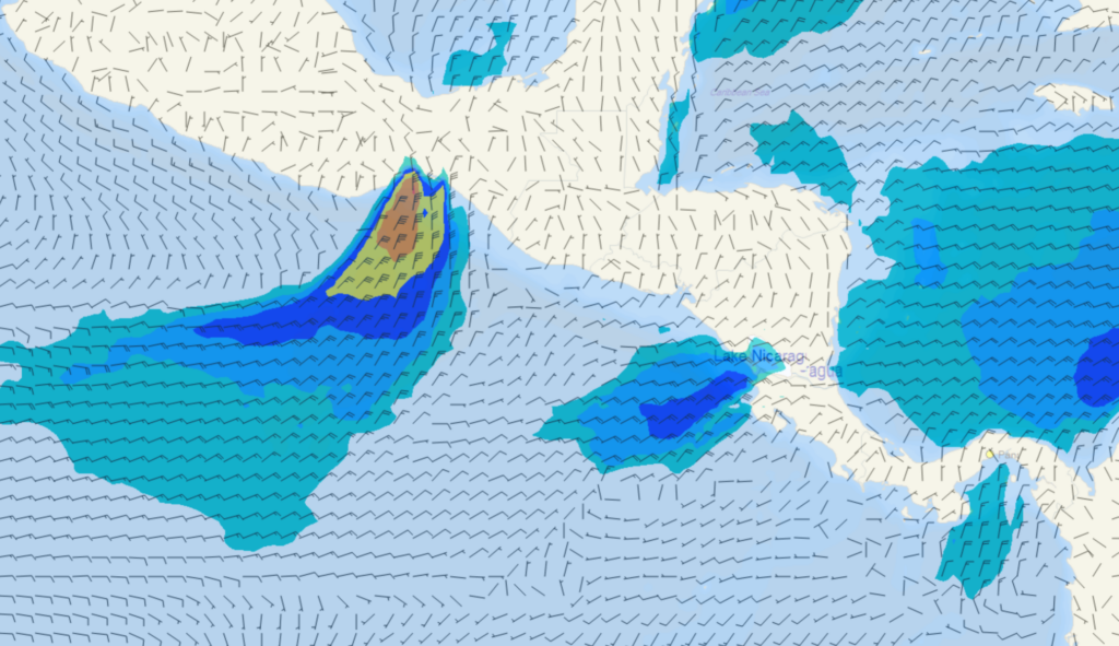
The Tehuantepecer is one of three local gap winds in the region. Similar events also occur in the over the Gulf of Papagayo and the Panama Canal, producing the Papagayo and the Panama jets respectively as illustrated in the image below using GFS for 4/12Z Jan 2022.

Stay connected and safe.