After a very busy stretch of tropical activity across the Western Hemisphere over the last few months, a relatively quiet period has occurred over the last 10 days over the north Atlantic and Eastern Pacific hurricane season. That could change over the next two weeks as the Madden-Julian Oscillation (MJO) is forecast to become active once again, and enter phases 8, 1, and 2. This could facilitate the development of the Central American Gyre during that time, and spur possible development of a tropical cyclone.
What is the Central American Gyre?
The Central American Gyre is a broad low-level cyclonic circulation that develops in the vicinity of Central America. Its development has two known pathways:
- The first is a baroclinic pathway that involves an upper-level trough moving into the western Gulf of Mexico, leading to ample synoptic forcing for upward vertical motion and subsequent low-level circulation formation downstream of the upper-level trough as shown in Figure 1A.
- The second is a tropical pathway that involves the propagation of the MJO into phases 8, 1 and 2, which forces a westerly trade wind surge in the tropical East Pacific as indicated in Figure 1B.
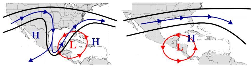
Figure 1A (left) schematic of baroclinic Central American gyre, Figure 1B (right)schematic of a tropical Central American gyre. (Source: http://www.atmos.albany.edu/student/ppapin/research_cag.php)
This tropical variety can also lead to the formation of tropical cyclones in the western Caribbean and East Pacific along its outer periphery. Formation is also climatologically favourable during specific times of the year, mostly confined to the shoulder periods of the Atlantic and East Pacific Hurricane Seasons (May-June, September-November) as shown in Figure 2.

Figure 2: Climatology of Baroclinic (Blue) and Tropical (Red) Central American Gyre formation between 1980-2010 (Source: Papin et al. 2017)
Over the next 10 days, both the ECMWF and GFS modelling systems have the MJO amplifying into Phases 8 and 1. However, there’s still disagreement between the two models, and their ensembles on how much amplification will occur, with the GFS being the more bullish of the two as shown at Figure 3. Of note, ECWMF underwent a major upgrade last week which included improvement in the skill to identify and forecast MJO, so it will be interesting to see how things pan out.
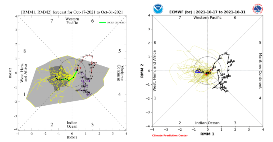
Figure 3: Latest MJO Ensemble forecasts from the GFS (Left) and ECMWF (Right) (Source: Climate Prediction Center)
We can see the development of the Central American gyre on both deterministic runs of the GFS and ECMWF from 17 October 1200 UTC valid October 24th (Fig. 4). The gyre is characterized by a broad circulation with easterlies present over the Caribbean and westerlies over the East Pacific. Additionally, we see a decentralized lobes of vorticity in association with the gyre. These lobes of vorticity can consolidate into tropical cyclones if given enough time in favourable conditions.
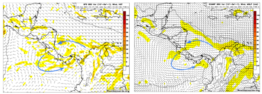
Figure 4: 850 Wind and Vorticity from 17 October 1200 UTC GFS (Left) and ECMWF (Right) runs valid 24 October (Source: Weathernerds.org)
Diving deeper into the model forecasts, Figure 5 shows ensemble members from the GFS (left) and ECMWF (right) showing possible tropical cyclone development on the western periphery of the Central American gyre in the East Pacific within the next 10 days. The GFS ensembles are notably the more aggressive ensemble suite, with more members showing significant development compared to the ECMWF, which might be tied to the stronger MJO pulse the GFS shows around the same time. So, after the reprieve of activity over the last 10 days, it appears that the tropics may be poised to reignite with late-season activity as we head deeper into the second half of October.
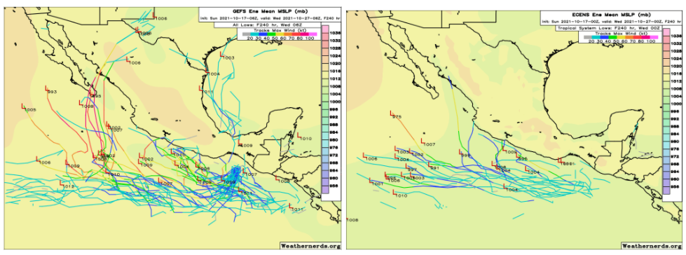
Figure 5: Ensemble low and track forecasts from the 17 October 0600 UTC GFS (Left) and Ensemble forecasts from the 17 October 0000 UTC ECMWF (Right) valid 27 October (Source: weathernerds.org)
Atlantic Basin – Reserve List Names
If the tropics do reignite, then Mid to late October still leaves a significant portion of the traditional hurricane season still to run, especially now that we have returned to La Nina conditions in the Pacific. With 20 of the 21 names already used this season for the Atlantic basin (only Wanda left remaining) it looks like the ‘extra’ hurricane name list will be used for the first time. Previously, if the Atlantic basin surpassed 21 named storms then the Greek Alphabet was used. However, the World Meteorological Organization (WMO) has changed the system this year to use a reserve or auxiliary list of names of which the first 6 are: Adria, Braylen, Caridad, Deshawn, Emery and Foster. For now, the 2021 season in the Atlantic is set to closely follow 2020’s record breaking season. Stay tuned for further updates.
Stay safe and connected.