The 2022 Atlantic Hurricane season is currently in the midst of an unusual quiet streak with tropical development, with Colin being the last system back in Early June. Only three tropical storms have formed in the basin so far this year (fig. 1), which has been below expectations from the preseason outlook. With almost half the season behind us, will the second half be as quiet as the first?
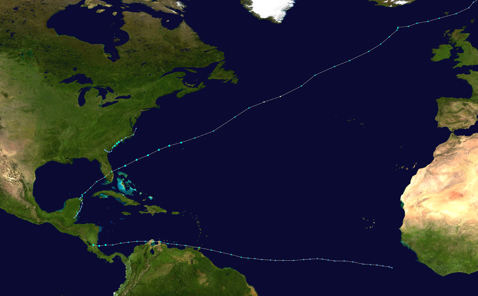
Fig 1, 2022 Atlantic hurricane Season Observed Storm Tracks through August 21st. Source: Wikipedia
First, we’ll take a look at sea surface temperature (SST) anomalies across the East Pacific and Atlantic. The main development region (MDR) is running warmer than normal, which will act to promote development as we head closer to peak season (September 10th). A colder than normal Canary Current has been persistent for much of the year, and will likely persist moving forward. A colder than normal canary current promotes mid-level dry air intrusions into the MDR, which can hamper development, and has plagued the MDR thus far this season. This can also reinforce the intensity of the dusty, dry Saharan Air Layer blanketing across the Atlantic Basin (figure 2).
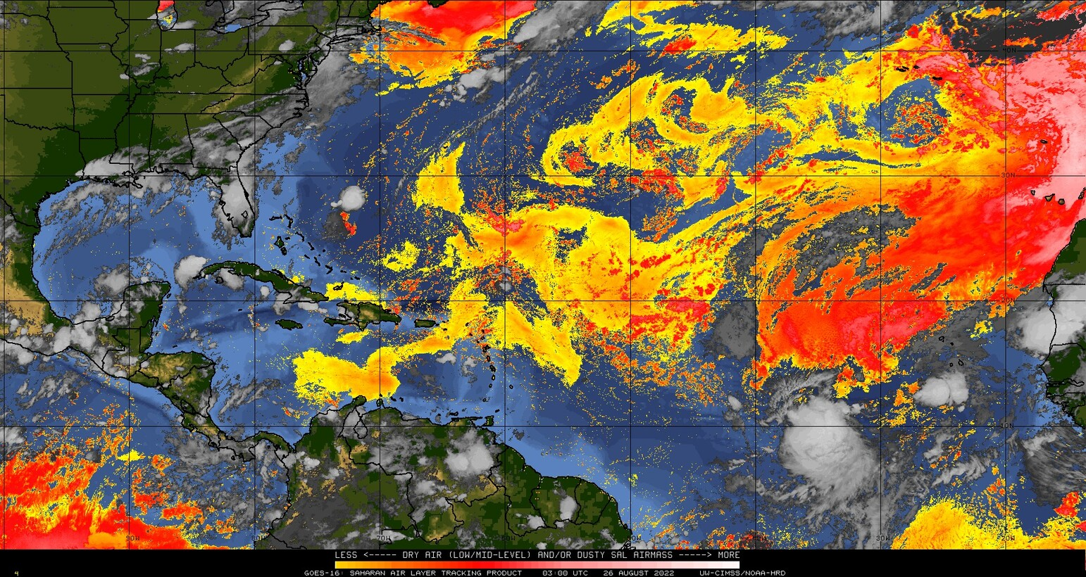
Figure 2: Saharan Air Layer Denoted in “Warm” Colors, valid August 26, 2022
A warmer than normal western Atlantic Basin continues, and may promote development of any tropical disturbances that fail to develop in the MDR due to dry air. Lastly, La Niña continues across the equatorial Pacific, which has been a persistent feature for the third hurricane season in a row. La Niña typically reduces wind shear over the western Atlantic, and isn’t a hindrance to tropical development in the Atlantic, unlike El Niño.
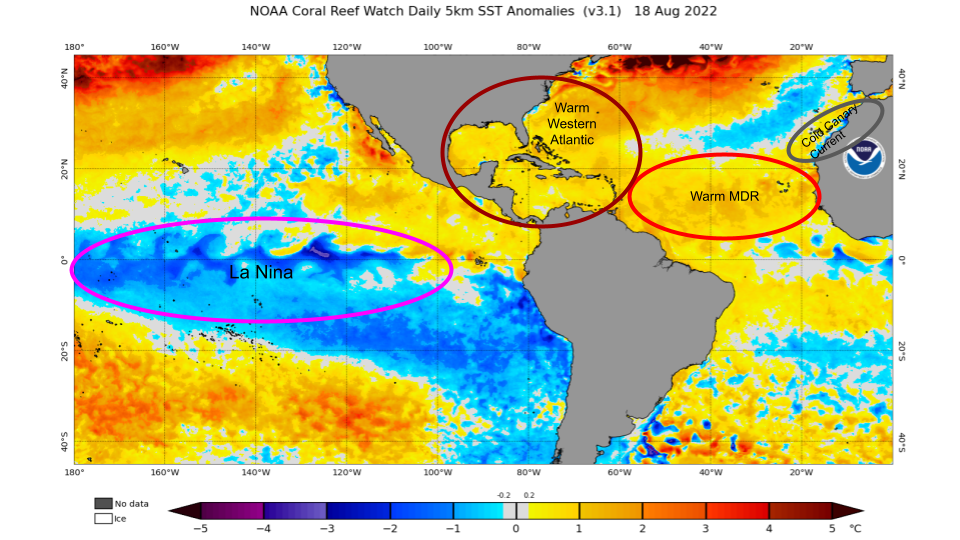
Figure 3. Sea Surface Temperature anomalies valid 18 August 2022. Source: NOAA
Next, we’ll take a look at the prospects for tropical development over the next two weeks. The Madden Julian Oscillation (MJO) is a component of intraseasonal variability across the tropical regions on Earth, and can play a role in promoting or inhibiting tropical development. The GFS (figure 4) and ECMWF (figure 5) MJO forecasts generally agree that the active phase will move through the African continent and Indian Ocean, or phases 2 and 3 over the next two weeks. Phases 2 and 3 are generally favourable across the Atlantic Basin because the MJO acts to reduce wind shear and moistens the large-scale environment across the MDR.
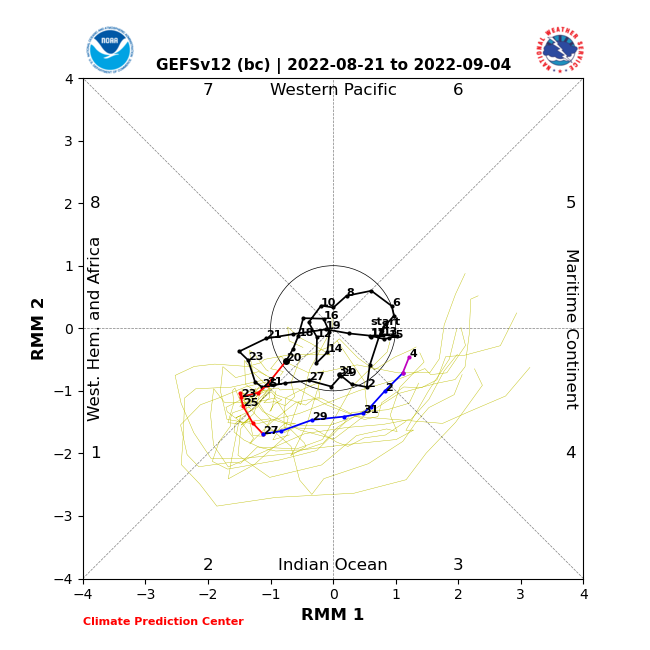
Figure 4: MJO forecast from 21 August 1200 GMT GFS model forecast. Outer axis represents amplitude, inside axis represents MJO Phase. Source: Climate Prediction Center
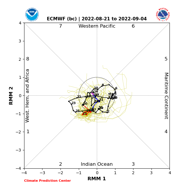
Figure 5: MJO forecast from 21 August 1200 GMT ECMWF model forecast. Source: Climate Prediction Center
The latest ECMWF ensemble forecast (Figure 6) shows 30-40% odds of tropical cyclone formation across the MDR over the next 10 days, with a weaker signal showing S of Bermuda. As we head closer to peak season, and with a favourable MJO, these odds could increase as September nears.
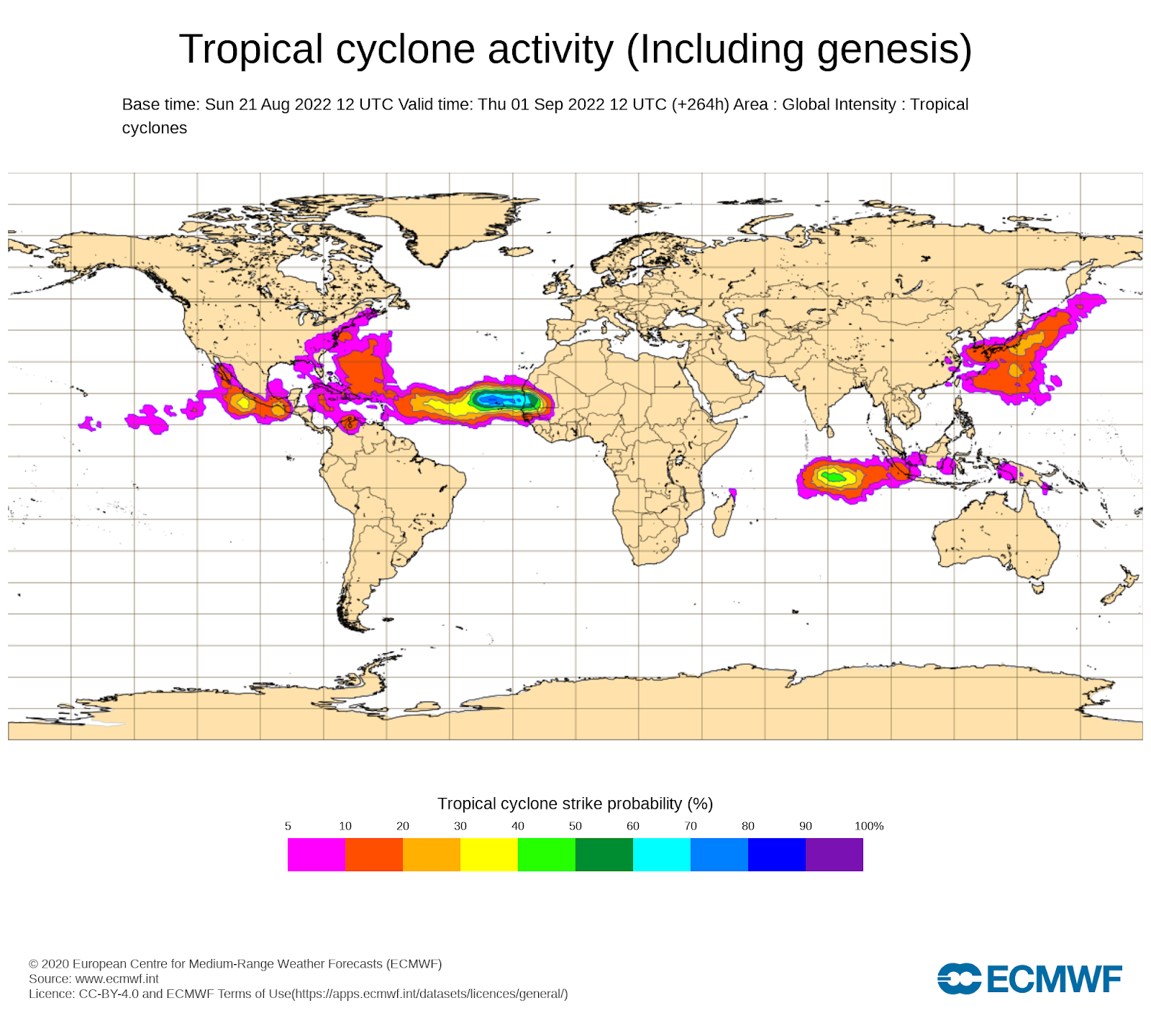
Figure 6: ECMWF ensemble forecast tropical cyclone formation probabilities.
Lastly, we’ll examine what we could expect after peak season passes. La Niña is expected to persist through the rest of hurricane season, with 70% odds of La Niña extending into early winter. La Niña can extend tropical cyclone activity into October and November across the Atlantic Basin by decreasing shear across the Caribbean and Gulf of Mexico. With anomalously warm SSTs across this region, we may have a higher risk of tropical cyclones in this part of the basin past peak season (October-November).
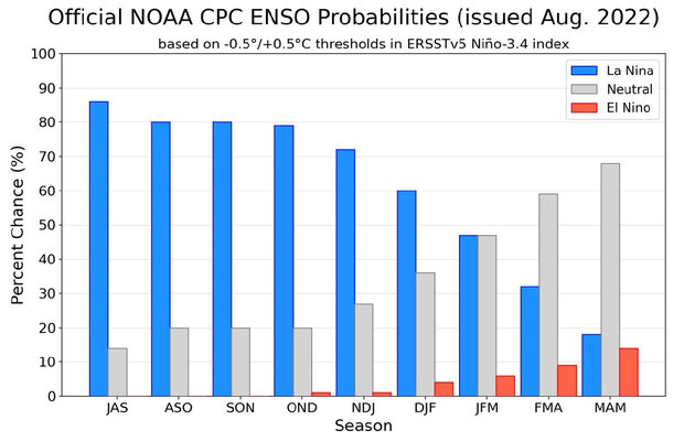
Figure 7: ENSO Forecast Probabilities issued August 2022. Source; NOAA
With much of the first half of the season devoid of significant tropical cyclone formation, we are lowering our pre-season expectations (found in our pre-season blog here) of 20 named storms, 10 hurricanes, and 4 major hurricanes down to 16 named storms, 8 hurricanes, and 3 major hurricanes.
Tropical Cyclone forecasting is often a complex process, and requires continuous monitoring by marine routers. Hurricane season can “flip the switch” very quickly and can occur with little lead time. As always, Fleetweather will be here to tackle any challenges hurricane season may pose to the shipping industry.
Stay connected and safe.