July has turned out to be quite an active month in the North Atlantic. The experts, with unusual consensus, have been predicting and continue to predict an above average season. We have just had the first hurricane of the 2020 season with Hurricane Hanna being classed as a Cat 1 storm over the weekend and now dissipating over Mexico.
Interestingly, according to the National Oceanic and Atmospheric Administration (NOAA) based on historic averages we would not expect an 8th named system until 24th September, so we could use up all 21 names this season. In the event this occurs, then additional storms will take names from the Greek Alphabet. The first time this ever happened was in the record breaking 2005 season when Tropical Storm Alpha formed on 20 October; the 23rd named storm that year. This beat the previous record season of 20 named storms in 1933.
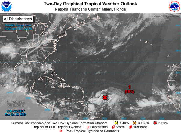
Meanwhile, we have another system being monitored as Invest 92L by the National Hurricane Centre (NHC) who gives this system an 80% chance to develop in the next two days and 90% over the next 5 days. Currently (28 Jul 00:00 UTC) 92L is a weak and disorganized system associated with an easterly wave along 48W (some 680nm east of Barbados). Environmental conditions are expected to become more favourable over the next few days as it tracks west-northwest at 13-17 knots affecting portions of the Leeward Islands later on Wednesday 29th Jul and northern Greater Antilles/Bahamas thereafter.

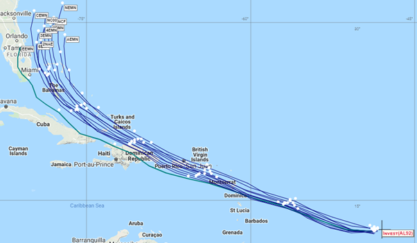
This image from NOAAs Hurricane Forecast Improvement Program (HFIP) experimental tropical storm tracks shows the single model ensembles are in good agreement over the next 6 days (white dots show 24 hr intervals).

It looks like 92L is set to become the 9th named storm in late July compared with a 4th October average for that benchmark. We have yet to get through the peak season which runs from mid-August to late October, so things are certainly hotting up and new records look increasingly likely to be set.