These are busy times for ship routing companies. With attention focused on an above average, record smashing 2020 North Atlantic hurricane season the Mediterranean is now making an appearance with its own “cyclone” in the Ionian Sea over the next few days.
Mediterranean tropical-like cyclones, often referred to as “medicanes” or “Mediterranean cyclones” are storms with subtropical and tropical characteristics that form in the Mediterranean Sea. Similar to tropical cyclones, these are warm core systems which closely resemble tropical cyclones in satellite images.
Well developed medicanes have tropical or ‘hurricane’ characteristics, with clear circular eyes, surrounded by an eye wall and circular cloud patterns. They typically reach gale to storm force strength, but the strongest have reached Category 1 hurricane strength in the past. Medicanes occur year-round, with activity historically peaking between the months of September and January, 1 -2 times each year on average.

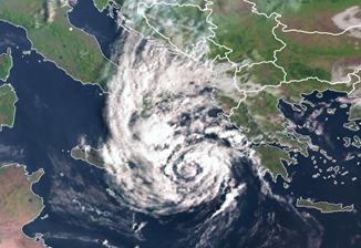
This EUMETSAT image for 0600UTC today shows a ‘cyclone like’ medicane over the Ionian Sea which is taking advantage of weak upper level shear in the region coupled with the warm waters of the Mediterranean. The system is expected to swing east over the Ionian Sea towards the Ionian Islands and Greece by Friday morning. It is then expected to recurve SE and weaken over the SW Peloponnese over the weekend before dissipating over the western Levantine Basin on Monday.
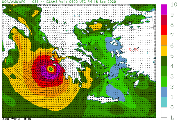
This wind image for Friday 18th September 0600UTC below from the Greek high resolution ICLAM model (Integrated Community Limited Area Modelling System) shows surface winds speeds are currently predicted to reach around Beaufort Force 9-10 (high end Tropical storm) with gusts to “Category 1” status during Friday.

These extreme weather events can have serious consequences for mariners and those ashore.
Stay connected and safe.