Here is our follow-up North Atlantic Tropical Outlook updated from our initial look in April. Since then modelling has come into better agreement and overall we can expect an above average hurricane season for the North Atlantic in 2021. Here is why.
Sea Surface Temperature (SST)
The subtropical North Atlantic (SSTs) remain well above normal, while the main development region has also warmed to above average over the last month. Cool-neutral ENSO and the persistence of negative PDO across the mid-latitude Pacific is expected to put a damper on any expectation for an above-average East Pacific Hurricane Season. Despite this, a small warm anomaly exists along the Mexican coastline in the tropical NE Pacific. This may help foster more tropical activity across the Northeast Pacific compared to 2020, which will increase wind shear across the Caribbean during peak season, and subsequently decrease tropical cyclone activity in the Caribbean compared to 2020.
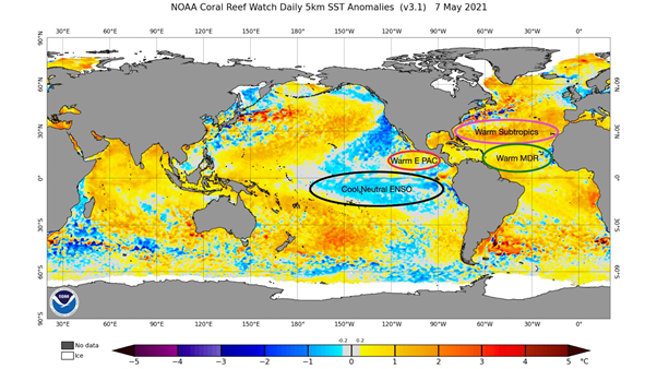
Current Sea Surface Temperature Anomalies as of 7 May 2021, Source: www.ospo.noaa.gov
Models continue to have disagreements on the evolution of ENSO during the course of hurricane season. The ECMWF forecast remains warmer than most other model solutions with continued warming into warm-neutral or even weak El-Nino territory by late summer. NCEP/NOAA is much colder with ENSO remaining cool-neutral through summer, then a resurgence of La Nina by late season.
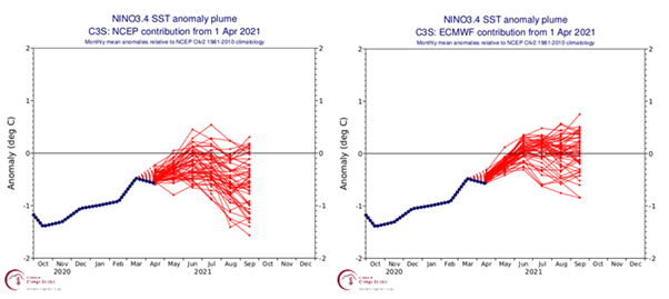
Sea surface temperature (SST) forecasts for NINO 3.4 from NCEP (left) and ECMWF (right) Source: Climate.copernicus.eu
There are several things we need to note when looking at the latest ECMWF. The latest available forecast has trended colder with ENSO, especially late in the hurricane season, compared to the previous forecast cycle in March. Additionally, if we examine the April 2020 ENSO forecast from the ECMWF, the entire ensemble suite was too warm with ENSOs evolution during the 2020 hurricane season. Given the above information, current expectations keep cold-neutral ENSO in place through mid-summer, with the possibility of a resurgence to La Nina possible by late hurricane season (October-November). So, overall there is unlikely to be any significant El Nino effect.
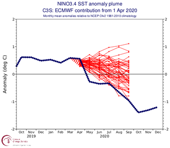
Sea surface temperature (SST) forecasts for NINO 3.4 and verification from April 2020 ECMWF Source: Climate.copernicus.eu
Accumulated Cyclone Energy (ACE)
Next, we’ll take a look at ACE forecasts from the ECMWF seasonal guidance. ACE is another way meteorologists assess how active a hurricane season will be. It is a metric that takes into account the strength and length of time of individual tropical cyclones during their lifetime. The latest ECMWF guidance is the highest forecast ECMWF has provided since 2010 with 1.2 times higher than the average ACE of 105 in the Atlantic. However, the forecast spread still cannot discount a slightly below-average ACE for the 2021.
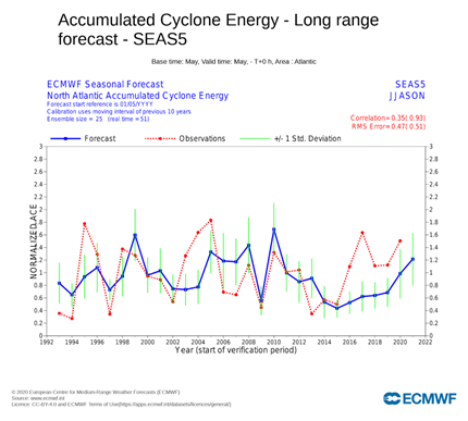
ECMWF May forecast of accumulated cyclone energy (ACE) for the Atlantic Basin between April-November. Source: Climate.copernicus.eu
Analogs
Lastly, we will examine hurricane season analogs, which can be used to assess seasons with similar initial conditions and comparative evolutions to what we expect for the upcoming hurricane season. The top five analogs we selected for this hurricane season include 1996, 2001, 2008, 2011, and 2017. These seasons saw an average of 17 named storms, 8 hurricanes, and 4 major hurricanes. They all featured decaying La Ninas entering spring, and remained cold neutral through peak season. Some years selected also had a resurgence into a second La Nina episode by mid-autumn, including 2008, 2011, and 2017. All analogs selected primarily had tropical activity during peak season confined to the MDR and subtropics, with 2008 featuring late-season Caribbean activity due to the resurgence of La Nina.
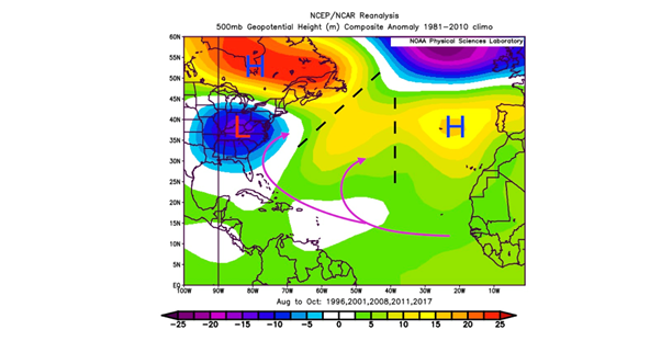
500mb Geopotential Anomalies for August-October in analog years (1996, 2001, 2008, 2011, 2017) using the NCEP-NCAR Reanalysis Source: psl.noaa.gov
If we look at the upper-level steering pattern during peak season (August-October), we can see these analogs featured ample mid-latitude blocking in association with ridging over the Azores and Maritime Canada. An anomalously strong cut off low was also centred over the Ohio Valley during these years. Breaks in the ridging allowed systems originating from the MDR to recurve out into the open Atlantic, which a secondary recurve track along the eastern Greater Antilles, Bahamas, and US East Coast.
Summary
Most model forecasts indicate an ENSO cool-neutral state, with the possibility of La Nina re-emerging by late in the hurricane season. Warmer than average SSTs are expected to remain across the Atlantic MDR and subtropical regions through peak hurricane season. Early-season activity in June-July will be focused in the Gulf of Mexico and off of the US East Coast, where tropical transitions over warmer than average SSTs will be possible. Most of the activity during peak season (August-October) will be focused in the Atlantic MDR where the Easterly African Wave train is expected to be active. Most model forecasts are favouring two recurve track regimes out of the MDR, one focused over the open Atlantic to the east of Bermuda. The other focused near the vicinity of the Windward Islands, Bahamas and US East Coast.
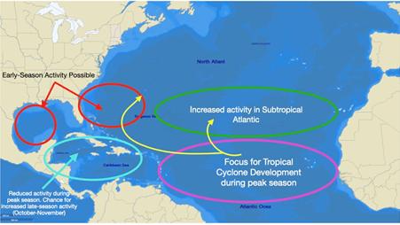
2021 Atlantic Hurricane Outlook Map
The anonymously warm subtropical SSTs will help maintain tropical cyclones as they recurve out of the MDR. The Caribbean is expected to remain less active than 2020 due to more tropical activity in the East Pacific and ENSO neutral conditions through most of the 2021 hurricane season. However, a window of increased activity may be possible late in the season (October-November) with the development of the Central American Gyre and redevelopment of La Nina.
So our current expectation for the 2021 season is for above average with 18 named systems, 9 hurricanes, and 4 major hurricanes. This is inline with Tropical Storm Risk (TSR) who are predicting 17, 8 and 3 while Colorado State University (CSU) is predicting 17, 8 and 4 respectively.
Watch this space for further updates. Meanwhile stay connected and safe.