Growing up in northeastern Pennsylvania, I have always had a great passion for winter weather, specifically big East Coast snowstorms. With winter being my favorite season, I am always looking for favorable environmental factors that are conducive for a big Nor’easter, including the cold air needed to get snow rather than rain. Nor’easter is a term used to describe a strong low pressure area which moves poleward along the U.S. Eastern Seaboard, with the word originating from the strong NE’ly winds that usually occur over coastal areas.
One of the important things to look at when evaluating if a pattern is conducive to a Nor’easters development are teleconnections, or significant relationships between certain large scale weather features and the general effects they have on temperature and precipitation patterns in certain geographic regions.
The North Atlantic Oscillation
For East Coast U.S. winter weather enthusiasts, the North Atlantic Oscillation (NAO) and Arctic Oscillation (AO) are two important teleconnections to consider. Both of these teleconnections have a positive and negative phase, with different effects on East Coast weather. For the NAO, a positive phase indicates persistent lower pressure over the high latitudes of the North Atlantic ocean (specifically near Greenland), with persistent higher pressure over the Eastern U.S. and central North Atlantic ocean. This generally means an unfavorable jet stream pattern for winter weather/storms over the Northeast U.S., with warmer temperatures expected.
For the negative phase of the NAO, the pattern is reversed with persistent lower pressure over the Eastern U.S. and central North Atlantic ocean, and higher pressure over the high latitudes of the North Atlantic ocean. Please see below diagram for the expected conditions with a negative versus positive NAO.
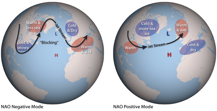
Figure 1: Expected conditions in a Negative and Positive North Atlantic Oscillation (NAO).
The negative phase of the NAO is favored for winter weather along the U.S. east coast, due to the persistent trough (lower pressure) over the eastern U.S. and persistent ridge (higher pressure) near Greenland. This can support the necessary cold air over the Northeast U.S. (to receive snow). This also favors the mid-latitude Polar Jet Stream dropping down towards the Southeast U.S. and potentially “phasing together” with the Subtropical Jet Stream, then turning NE off the southeast U.S East Coast and running along the seaboard. This scenario favors storm development sometimes starting in the Gulf of Mexico then moving off the SE U.S. coast, which allows storm systems ample moisture from the Gulf of Mexico and Atlantic Ocean. As the systems move up the eastern seaboard, the general strong temperature gradient between colder air over land and warmer air over the ocean provides the fuel for systems to continue to develop, sometimes rapidly, especially in the case where the Polar Jet Stream and Subtropical Jet Stream phase together, with energy from both jet streams merging together, allowing for more significant storm development. When there is sufficient cold air in place over the eastern U.S. this can lead to big snows for the region. The below satellite image is an example depicting the Polar Jet Stream Phasing together with the Subtropical Jet Stream during the Presidents Day Storm of 1979.
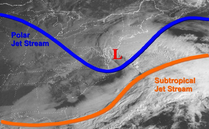
Figure 2: Satellite image of phasing of Polar and Subtropical Jets during President’s Day Storm of 1979.
There are two main classifications of Nor’easters, which are Miller A and Miller B type storms. A Miller A is as noted above where storms develop over the Gulf of Mexico/SE U.S. coast and move up the seaboard. A Miller B on the other hand occurs when an area of low pressure over the central U.S. moves east towards the Appalachian Mountains, with this inland low then weakening due to the interaction with the Appalachian Mountains. The energy from the inland low then transfers towards the coast, with a new low pressure area developing off the East Coast. This low then follows a similar track to a Miller A. Both types of Nor’easters can yield significant precipitation amounts, however Miller B systems often have a zone where less precipitation falls (areas that fall between the weakening inland low, and the new low developing further east off the coast).
With a negative NAO in place, the jet stream becomes meridional (more north to south variation) across the North Atlantic, with systems off of the U.S. East Coast moving slowly eastward compared to a more zonal west to east flow where systems move quickly eastward (positive NAO). This is due to the “blocking” high pressure area generally found over Greenland acting to prevent systems from quickly moving east and sometimes even causing Nor’easters to stall off the NE U.S. coast for a time. This leads to higher precipitation totals due to the prolonged duration of the storm for a given location.
Teleconnections such as the NAO are forecasted by weather models such as the American GEFS (Global Ensemble Forecast System). See example graphic below. Other teleconnections are forecasted in the same manner, some of which will be talked about later.
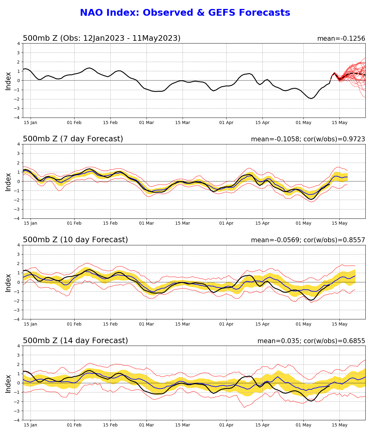
Figure 3: Example from GEFS showing expected Positive, Negative or Neutral NAO forecasts.
Mainly focusing on the top graph, the solid black line indicates the observed NAO index from mid January to 11-May, with the dotted black line representing the mean forecast of the GEFS through the end of May (where the red lines indicate the forecast of each ensemble member, showing the variability in the forecast). Overall, much of the Northeast U.S. had little snow and cold air this past winter season (2022-2023).
Looking at the observed NAO values, it can be seen that the NAO was positive until the very end of February, which explains the lack of snow and cold in the Northeast. Then, the NAO became negative for the first half or so of March, and during this time the mountainous areas of the Northeast U.S. (especially New England) did receive some heavy snowfall. Being later in the season and with the power of the sun getting stronger, coastal areas and lower elevations received little to no snow. There was a Nor’easter from March 14th-15th which dropped significant snow in much of the northeast (see below image of snow totals), where amounts in excess of 30 and even 40 inches occurred in places from the Catskills north and east towards the Adirondacks, Berkshires, and Green and White Mountains. The sharp drop in snow totals is evident further towards the coast, and in lower elevation areas.
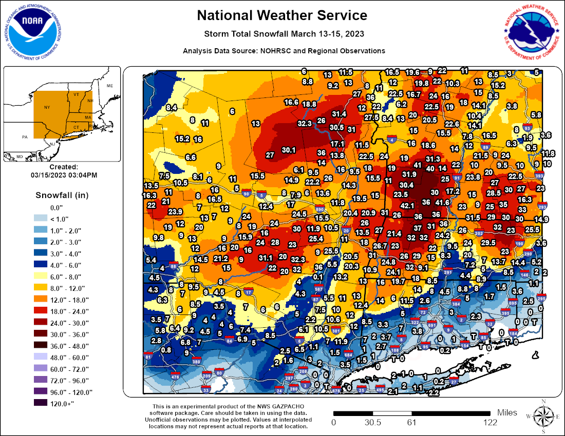
Figure 4: Storm Total Snowfall graphic from National Weather Service of the New England region.
The Arctic Oscillation
Moving on to the AO which is highly correlated with the NAO, a negative phase (as with the NAO) is favored for possible Nor’easters and normal to below normal temperatures along the U.S. East Coast. In the negative phase, the Polar Jet Stream is weaker and has more north to south variation, allowing cold air to be able to move S’ward into mid latitudes (more meridional flow). A positive AO on the other hand, means the Polar Jet Stream is stronger, further north, and more zonal, keeping cold air contained across polar regions (not good for snow in the Northeast U.S.). As noted above, being the AO and NAO are strongly correlated, many times both teleconnections have the same phase at a given time (both negative or both positive). Below is an image showing the general expected conditions compared to normal for a positive vs negative AO, with the negative phase showing lower pressure (purple colors) over the eastern U.S. and North Atlantic, whereas the positive phase shows higher pressure (orange colors) over the region. Lower pressure along the U.S. Eastern Seaboard generally translates to colder and more stormy conditions, whereas higher pressure generally translates to warmer and less stormy conditions.
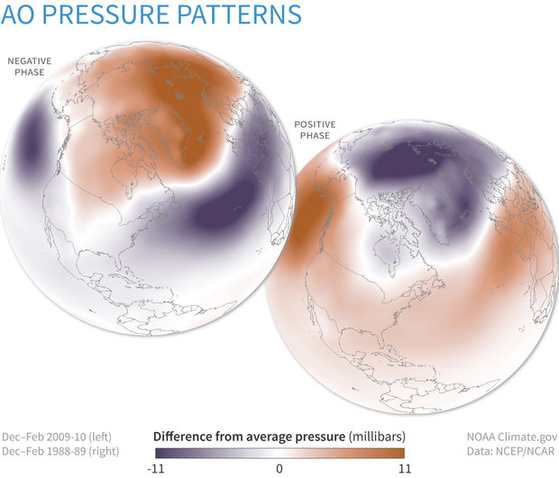
Figure 5: Expected pressure differences in the Positive versus Negative NAO patterns.
The Pacific North American Pattern
Another important teleconnection for Northeast U.S. winter weather not yet mentioned is the Pacific North American Pattern (PNA), which also has a positive and negative phase. The PNA, unlike the NAO and AO, has to do with the jet stream pattern over the Pacific and Western U.S. rather than the Atlantic. However, this causes downstream effects for the Eastern U.S. as well. In the negative phase, an area of lower than normal pressure (trough) is generally expected over the western U.S. with higher than normal pressure (ridge) over the eastern U.S. This is not favorable for Northeast U.S. winter weather with usually above average temperatures expected, due to a storm track generally more towards the Great Lakes (placing East Coast in warm sector of storms).
On the other hand, a positive PNA usually indicates higher than normal pressure over the Western U.S. (ridge) with lower than normal pressures over the Eastern U.S. (trough). This is favorable for Nor’easters along the U.S. East Coast, as with the trough over the eastern U.S. low pressure systems can gather moisture from the Gulf of Mexico before moving up the east coast (more moisture means more snow/precipitation). See below image for the general pattern expected with a positive versus negative PNA.
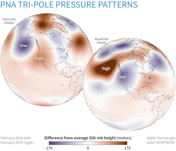
Figure 6: Expected 500mb height differences in positive versus negative PNA.
Taking all these teleconnections into account, if you have a +PNA combined with a -NAO/AO (teleconnections all favorable for winter weather in the east), chances are good for getting a potential Nor’easter. However, it should be noted that even when all the teleconnections are favorable, a Nor’easter is not guaranteed. Additionally, even if a Nor’easter occurs, precipitation falling as all snow is not guaranteed. Strong Nor’easters can bring in a large amount of warmer air from over the western Atlantic Ocean (generally NE’ly winds with a Nor’easter), possibly turning certain areas over to a wintry mix or rain (especially coastal regions). Even with favorable teleconnections, the exact placement of ridges and troughs can have a big effect on the outcome of a storm (track as well as precipitation type). So if even one feature is a bit off in placement, it can be detrimental for snow chances.
If only one or two of these teleconnections is supportive (+NAO/AO combined with +PNA, or -NAO/AO combined with -PNA), then this will many times cause the locations of the ridge and trough axes to be off. For example, storms may either be pushed further out to sea off the U.S. East Coast (not affecting land), or track inland towards the Great Lakes bringing warm air to the east coast (so generally a rain storm, or snow/ice turning over to rain if cold air is in place initially).
How Nor’easters impact Fleetweather’s marine clients
Shifting gears a bit, while these teleconnections are important for my shoreside life, they are also crucial to the weather patterns which affect Fleetweather’s clients at sea. Nor’easters have a big impact on the western Atlantic Ocean and ship routing. See below satellite image of basically the entire western North Atlantic being affected by a Nor’easter/Blizzard and the associated cold front in early January of 2018.
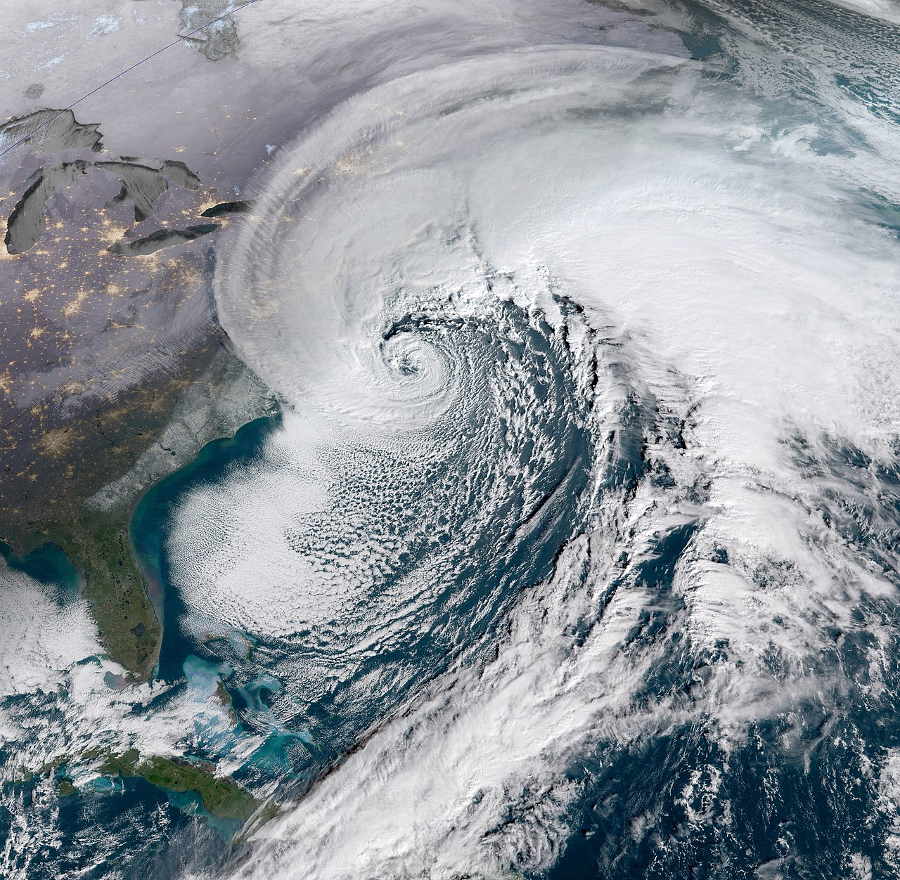
Figure 7: Satellite image of large Nor’Easter from January of 2018.
In regards to ship routing, a -NAO/AO generally means more heavy weather and associated challenging routing scenarios across the North Atlantic. As mentioned earlier, low pressure areas off the Northeast U.S. Coast generally become much stronger (Nor’easters), and move slower with a -NAO/AO, resulting in prolonged higher wind and sea conditions. These conditions can be very dangerous for ships, which is why it is important for marine meteorologists such as myself at Fleetweather to route vessels around these storms if/when possible, to avoid these conditions or at least minimize them.
A +NAO/AO generally implies the opposite for ship routing, with storms generally being weaker and quicker moving. This usually means more favorable routing conditions across the North Atlantic, but that is not to say there won’t be any heavy weather. There can still be successive lows impacting a given area with at least brief periods of heavy weather.
Finally, when adding in the effect of the PNA, a +PNA combined with a -NAO/AO would generally lead to the strongest storms along the East Coast of the U.S. with the highest potential for dangerous ship routing conditions. In strong winter storms, weather conditions can be just as bad as in a hurricane (depending on strength), with often times a larger area being affected by the high winds and seas compared to a hurricane. A +PNA and -NAO/AO combination would generally yield the highest probability for fully arisen seas. This is because with strong, slow moving storms, winds may blow over a given area for a long duration of time allowing seas to reach the maximum possible height for the given wind speed and fetch. When these teleconnection phases are reversed (-PNA and +NAO/AO), fully arisen seas don’t normally occur due to the generally quick moving and weaker storm systems associated with the more zonal jet stream flow.

Figure 8: Graphical example showing relationship of wind and waves, with longer fetch. Note that fully developed seas occur when wind occurs for a longer duration over a longer fetch.
When teleconnections are favorable for strong and slow moving storms, it is very important for marine meteorologists to closely analyze the upcoming pattern (both short and long range). If it is a close call (potentially unsafe) for a certain route in regards to potential heavy weather, it is always better to err on the side of caution with Safety of Life at Sea (SOLAS) being the top priority. In these cases a marine meteorologist should route the vessel a different way even if it means added mileage and time. Even if it looks like a vessel will “beat out” a storm, one must consider the fact that the vessel could be slowed further than expected in the heavy weather. Additionally, there is always the chance of engine issues, etc, which could place the vessel in a bad spot on a “close call” route.
Ship type and size comes into play as well, with vessels such as larger tankers being able to safely handle a higher degree of heavy weather than, say, a container ship. For smaller vessels or vessels more susceptible to rolling, it is better to route much more conservatively in the winter months, especially when a very active pattern is expected or ongoing. Even on a more conservative route, marine meteorologists always have to try to make sure the vessel has a “bail out” option in the case of upcoming heavy weather, which is why it is imperative to always closely monitor the long range weather forecast for significant changes.
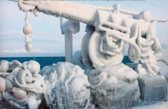
Figure 9: Ice accretion on ship machinery/equipment.
Freezing spray/ice accretion is another potential factor with big winter storms (see above image of ship that experienced significant freezing spray). It can happen with small storms as well, but it is generally much worse in larger storms that normally have higher winds and seas and for more prolonged periods. It usually occurs on the west side or “backside” of Nor’easters as they move up the coast. The generally north to northwest winds on this side of Nor’easters can bring cold arctic air from over land out over the western North Atlantic. When sea surface temperatures (SST’s) are sufficiently cold and there are strong winds to create sea spray, these combined conditions can lead to severe freezing spray in extreme cases, which would be detrimental to any ship. The colder the air and higher the wind speeds, the more ice accretion occurs on a ship. This can significantly affect ship stability, especially for ships that are less stable to begin with, with the possibility of capsizing being a real concern. Thus, marine meteorologists need to recommend options for avoiding or minimizing these conditions as much as possible. Some possibilities could be slowing a ship down to let the worst conditions pass (if ahead of vessel), having them remain at port longer (if not yet underway), increase speed to beat out the conditions, altering course to reach warmer air/sea, or having them shelter in lee of land (which may shield them from strongest winds and/or reduce fetch of the wind (thereby limiting the spray which could accrete)).
In conclusion, as with most things, certain weather events can be good or bad depending on your perspective. For Northeast U.S. residents that like snow and enjoy sports such as skiing, a +PNA and -NAO/AO is a dream pattern to have. On the other hand, for residents who don’t like winter weather, and for ships out on the ocean, a -PNA and +NOA/AO would be much preferred. But it’s not like we have a choice as it’s all up to mother nature in the end, so we just have to make the best of what we’re dealt with and prepare accordingly!
Stay connected and safe.