We are entering the middle of November where tropical cyclone activity in the Atlantic is expected to wind down before the end of the season on 30 November. However, we did see an uptick in tropical cyclone activity during early November. Since 31 October, we have had 3 named tropical cyclones: Hurricane Lisa, Hurricane Martin, and just recently Hurricane Nicole. In this blog, we will take a dive into what has been contributing to the increased tropical cyclone activity.

First, we will talk about climatology. While November is historically the quietest month in the tropical season, it is not uncommon to see a tropical cyclone or two in the Atlantic during November. In fact, we have seen at least one in the Atlantic every November since 2018. To help illustrate, Figure 1 above from the National Hurricane Center (NHC) shows the amount of activity, in terms of named storms, that occurs in the Atlantic each day from May 1 – Nov 30 within a 100 year period. We can see within the month of November, the basin seems to still be suitable for tropical cyclone activity.
However the area of activity shrinks to mostly within the Western Caribbean, off the US Southeast Coast and an area east of Bermuda centered over 30N/50W, as we can see in Figure 2 by the NHC.

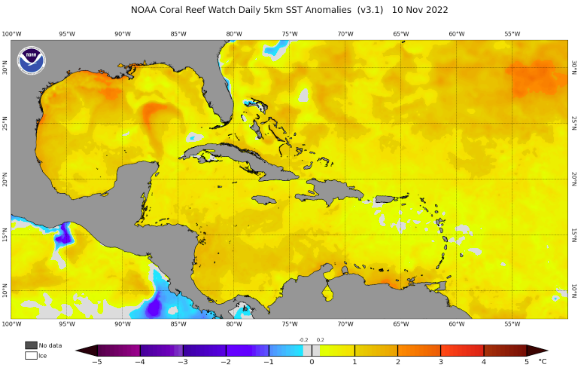
So how have the environmental conditions been for these areas? We’ll start by looking at the Sea Surface Temperature Anomalies. Figure 3 shows where as of Nov 10th, the sea surface temperatures within the Caribbean and subtropical Atlantic are warmer than usual as noted by the yellow/orange shading. In addition, we are still within an ongoing La Nina event, which promotes weaker wind shear across the tropical Atlantic. Given the abundant moisture and instability, these ingredients put together a favorable environment for tropical development.
As depicted in Figure 2, while the area of tropical activity remains small in November, these areas are within active shipping lanes where systems can pose a threat to vessels.
For example, since its genesis as a subtropical storm, the forecast path of Hurricane Nicole (Figure 4) involved crossing over the Bahamas and the Florida Strait. This would bring routing concerns for any vessels expected to transit within the Florida Strait or Northeast Providence Channel within the next 48-72hrs at the time. Some of Fleetweather’s routing decisions involved routing vessels away from the possible gale radius east and south of Florida and to transit within the Old Bahama Channel to remain at a safe berth south of the system.

In addition, Hurricane Martin also posed a threat to some Trans-Atlantic vessels. While model guidance confidence was high with the general track of the system moving NE, the larger threat was the system undergoing extratropical transitioning. This process involves the system rapidly moving towards the northeast into cooler water while the gale radius of the system increases as shown in Figure 5. With the quick nature of the system, vessels within the vicinity of the forecast track had to be monitored and the timeframe for routing decisions was short. In cases like these, vessels are usually recommended to adjust their speed or drift to avoid the growing gale radius and let the system pass ahead of them. Sometimes a route deviation away from the track is recommended as another possible option.


While these months in the Northern Hemisphere call for colder temperatures and even the chance for snow for some, we still have to be on our toes for any tropical or subtropical development that pops up. The North Atlantic Storm Track has been quite active already throughout much of November and the addition of a tropical cyclone in the mix makes the basin packed with activity. Regardless of the nature of the weather systems, Fleetweather continuously monitors the conditions across all ocean basins and will continue to provide safe and efficient weather routing to your vessels 24/7/365.
Stay connected and safe.
