Tropical cyclone season has arrived in the Eastern Pacific, and is fast approaching in the Central Pacific. Hurricane season begins 15 May in the Eastern Pacific and 1 June in the Central Pacific, and lasts through 30 November. Meanwhile, tropical cyclones can form year-round in the Western Pacific due to the constant presence of warm sea surface temperatures (SSTs).
Already, three tropical cyclones have formed in the North Pacific, all in the Western basin. Tropical Depression 01W formed in late March, and made landfall in Vietnam soon after. About a week later, a second tropical cyclone developed over the Western Pacific, which eventually strengthened into category 4 Typhoon Malakas. Around the same time, Tropical Storm Megi developed east of the Philippines, and made multiple landfalls in the island nation a few days later.
BACKGROUND
For the purpose of tracking tropical cyclones, the North Pacific is divided into three basins, each of which is monitored by its own Regional Specialized Meteorological Center (RSMC).
The Eastern Pacific basin encompasses the portion of the North Pacific east of 140W longitude, and is monitored by the National Hurricane Center in Miami, Florida. This basin averages 15 named storms, 8 hurricanes, and 4 major hurricanes each year.
The Central Pacific basin is located between 140W and the International Dateline, and is monitored by the Central Pacific Hurricane Center in Honolulu, Hawaii. This basin averages 4 named storms, 3 hurricanes, and 2 major hurricanes annually.
The Western Pacific basin encompasses the region between the International Dateline and 100E, and includes the South China Sea. This basin is monitored by the Japan Meteorological Agency in Tokyo. The Joint Typhoon Warning Center also issues tropical cyclone advisories in the Western Pacific, as do agencies in the Philippines and Hong Kong when systems approach their respective areas. The Western Pacific is by far the most active basin on Earth, producing 26 named storms, 16 typhoons, and 8 super typhoons in a typical year.
When creating outlooks for upcoming tropical cyclone seasons, experts examine a variety of long-range weather and ocean patterns. Among the most relevant teleconnections in the North Pacific are the El Niño-Southern Oscillation (ENSO), the Pacific Decadal Oscillation (PDO), the Atlantic Multi-Decadal Oscillation (AMO), and the Indian Ocean Dipole (IOD). Model forecasts of Accumulated Cyclonic Energy (ACE) for each basin are also useful to assess when analyzing long range outlooks.
ENSO
ENSO describes fluctuations in the SST pattern in the equatorial Pacific, and the resulting atmospheric responses. ENSO is divided into three phases: El Niño, La Niña, and Neutral. An El Niño occurs when SSTs in the equatorial Pacific are significantly warmer than average, while a La Niña occurs when the SSTs are significantly cooler than average. When there are no significant SST anomalies in the equatorial Pacific, then ENSO is in a Neutral phase.
This past winter, ENSO was in the La Niña phase for the second straight year. This La Niña has actually strengthened slightly over the last few weeks. Currently, models are split on whether La Niña will persist through the summer and fall or revert to Neutral. However, the latest expert consensus leans towards La Niña remaining in place for the rest of the year.
If La Niña remains in place, this would suggest below-normal tropical cyclone activity in the Eastern and Central Pacific due to cooler SSTs and increased wind shear. Meanwhile in the Western Pacific, La Niña does not necessarily have a significant impact on the total number of tropical cyclones. However, systems would be more likely to form further west in the basin closer to the Philippines, and would tend to embark on a westward track.
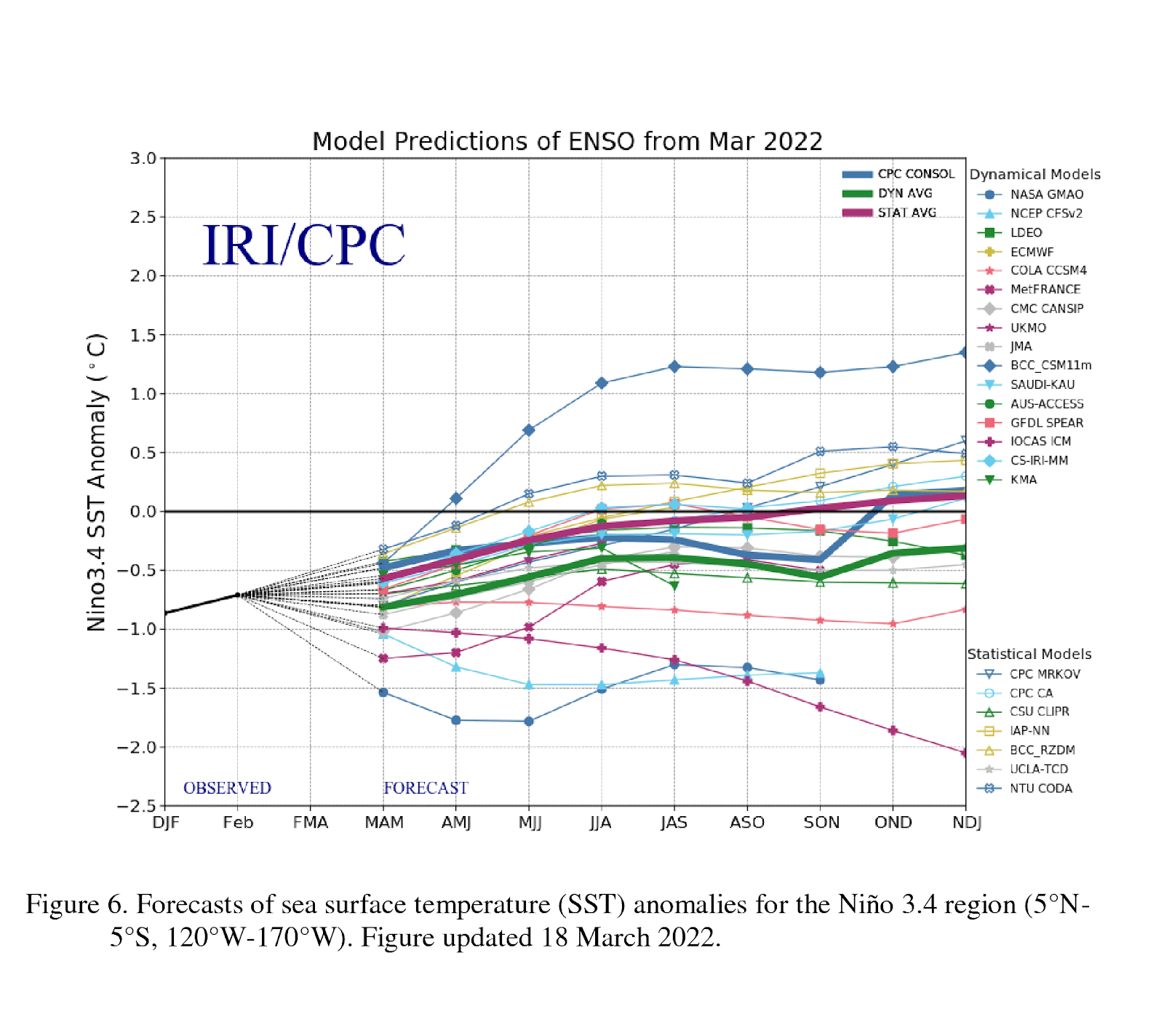
Model forecasts of SSTs in the Niño 3.4 region of the eastern equatorial Pacific, which is most commonly used to analyze ENSO. Note that the majority of models predict a continuation of La Niña. (Source: Climate Prediction Center)
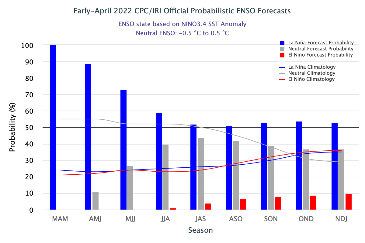
Expert forecast consensus of the probability of each ENSO phase for the remaining three-month periods of 2022 (Source: Climate Prediction Center)
PDO AND AMO
The PDO and AMO describe broad SST patterns in the Pacific and Atlantic Ocean, respectively. As their names imply, phases of these two patterns often last for several years, if not decades. Currently, the PDO is in a negative phase, which is expected to last for the rest of the year. A negative PDO indicates lower SSTs in the tropical Eastern and Central Pacific, leading to reduced tropical cyclone activity in these basins. Meanwhile, the AMO is in a positive phase, which is also expected to persist for the rest of the year. A positive AMO indicates warmer SSTs in the tropical North Atlantic and Caribbean Sea. The resulting increase in convection in these areas increases wind shear in the Eastern and Central Pacific, resulting in lower tropical cyclone activity.
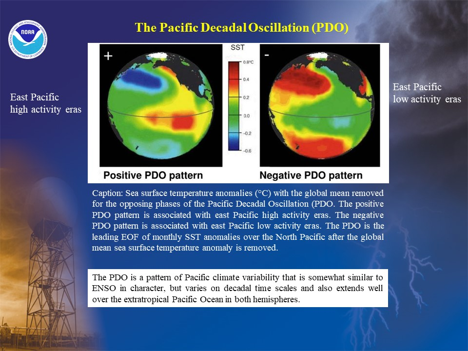
Typical SST patterns for the positive and negative phases of the PDO (Source: Climate Prediction Center)
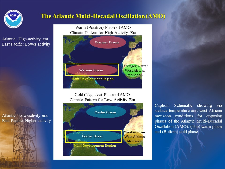
Typical patterns for the positive and negative phases of the AMO (Source: Climate Precidition Center)
IOD
The IOD describes the difference in SST between the western and eastern Indian Ocean. It is often closely linked to the ENSO phase. A positive (negative) IOD indicates that SSTs are warmer (cooler) in the western portion of the ocean in comparison to the eastern portion. A neutral IOD indicates no significant difference in SSTs between the two regions. Currently, the IOD is neutral. However, it is expected to trend negative this summer and fall. A negative IOD causes the monsoon trough in the Western Pacific to become weaker and retreat westward. This results in reduced tropical cyclone activity in the Western Pacific, with the westernmost portions of the basin becoming the favored area for genesis.
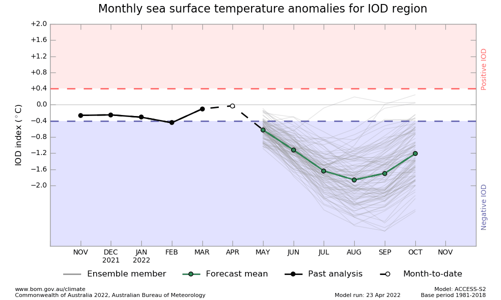
Ensemble model forecast for the IOD for this upcoming summer and fall (Source: Australian Government Bureau of Meteorology)
ACE
ACE can be calculated for each individual tropical cyclone based on the system’s duration and overall intensity. Therefore, adding up the ACE values for each system that develops in a basin gives a good idea of the overall activity for that basin’s entire tropical cyclone season. To that end, we can examine forecasts of ACE from the European Center for Medium-Range Weather Forecasts to supplement our outlooks. As shown in the charts below, the ECMWF model is forecasting below average ACE for the Western Pacific, and near normal ACE for the Eastern Pacific.
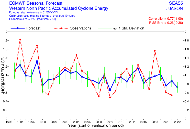
ECMWF ACE May forecasts for June-November in the Western Pacific, normalized based on the long-term average. For example, in May 2022, the product indicates 0.7 Normalized ACE, or 70% the long term average. (Source: ECMWF)
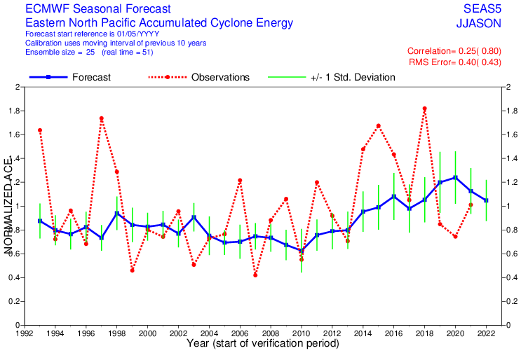
ECMWF ACE May forecasts for June-November in the Eastern Pacific, normalized based on the long-term average. For example, in May 2022, the product indicates 1.05 Normalized ACE, or 105% the long term average. (Source: ECMWF)
SUMMARY
For the Western Pacific, the presence of La Niña and the expected emergence of a negative IOD suggests that the favored formation area for tropical cyclones will be shifted westward in the basin, closer to the Philippines and in the South China Sea. These features also suggest a below normal typhoon season. The ECMWF forecast of below normal ACE lends credence to this idea.
For the Central and Eastern Pacific, the negative phase of the PDO and positive phase of the AMO both act to help suppress tropical cyclone activity. Furthermore, La Niña also tends to hinder tropical cyclone activity in these basins. Meanwhile, the ECMWF forecasts near normal ACE for the Eastern Pacific. Therefore, we currently expect near or below normal hurricane seasons in the Central and Eastern Pacific.
Of course, uncertainty always exists when making long-range weather and climate forecasts. The factors that were considered for this outlook will become more certain as the year goes on. It is also important to remember that even in below normal seasons, individual systems that do form can still have significant impacts.
Stay connected and safe.