The 2021 hurricane season stretched the above-average streak of tropical cyclone activity across the North Atlantic Basin to six straight years that started in 2016, with the 2021 season producing 21 named systems, 7 hurricanes, and 4 major hurricanes, exceeding average activity of 14, 7 and 3 respectively. With the start of the 2022 Atlantic hurricane season on our doorstep, do we expect a break in the Atlantic active streak, or will the Atlantic see its 7th straight active season?
Sea Surface Temperatures (SST)
The subtropical Atlantic SSTs remain generally above normal, which has been the case for the last few years. However, pretty steady cooling has been occurring since the onset of spring. Meanwhile, the opposite has occurred in The Main Development Region (MDR), where SST anomalies have risen from their minimum in early April because of weaker-than-normal easterly trade winds leading to less upwelling of cooler subsurface water . We will have to closely monitor these trends through the rest of spring, as a continuation may make significant tropical activity more likely.
Moderate La Niña remains in place across the tropical Pacific basin for the third straight year. In fact, this is only the fourth time since 1950 that a third year La Niña has occurred, with the others being 1956, 1975, and 2000. Additionally, a negative Pacific Decadal Oscillation (PDO) is locked in across the NE Pacific, which is characterised by a blob of above average SSTs south of the Gulf of Alaska surrounded by a half-ring of below-average SSTs along the western North America Coast. A negative ENSO and PDO will likely dampen tropical activity across the Eastern Pacific, and limit wind shear affecting the Gulf of Mexico, Caribbean Sea, and Western Atlantic.
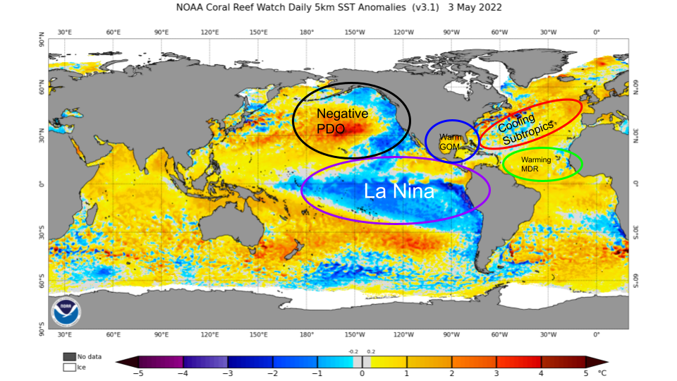
Current Sea Surface Temperature Anomalies as of 3 May 2022, Source: www.ospo.noaa.gov
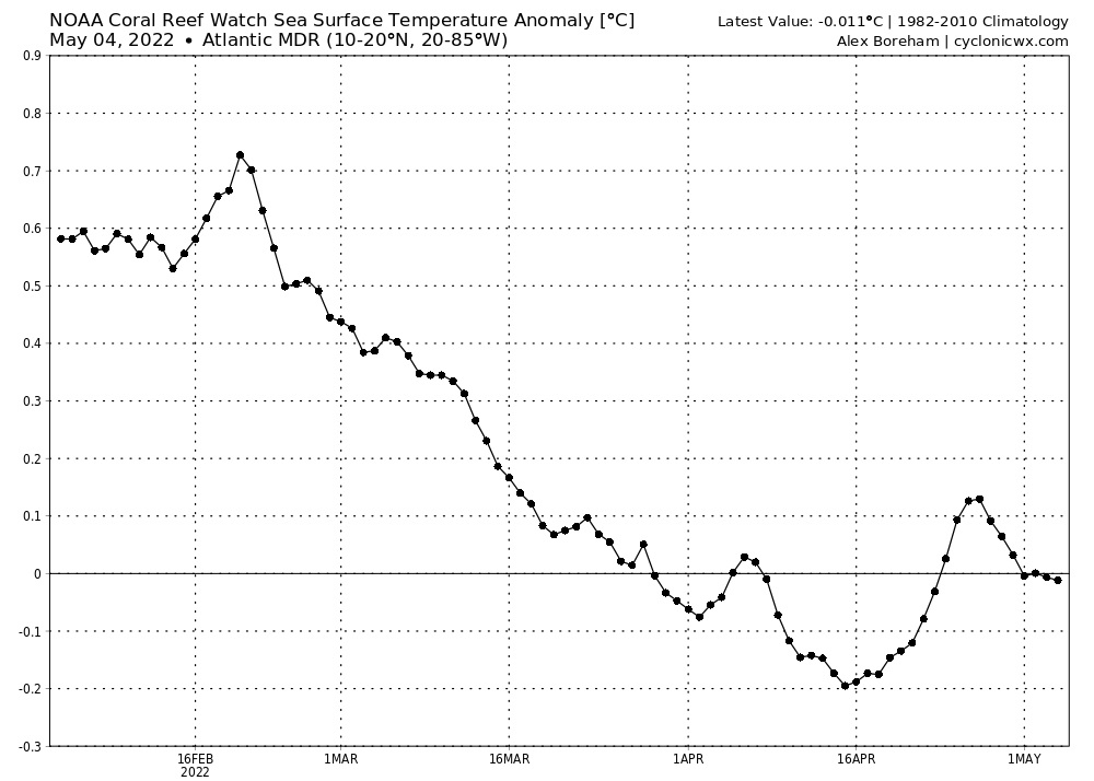
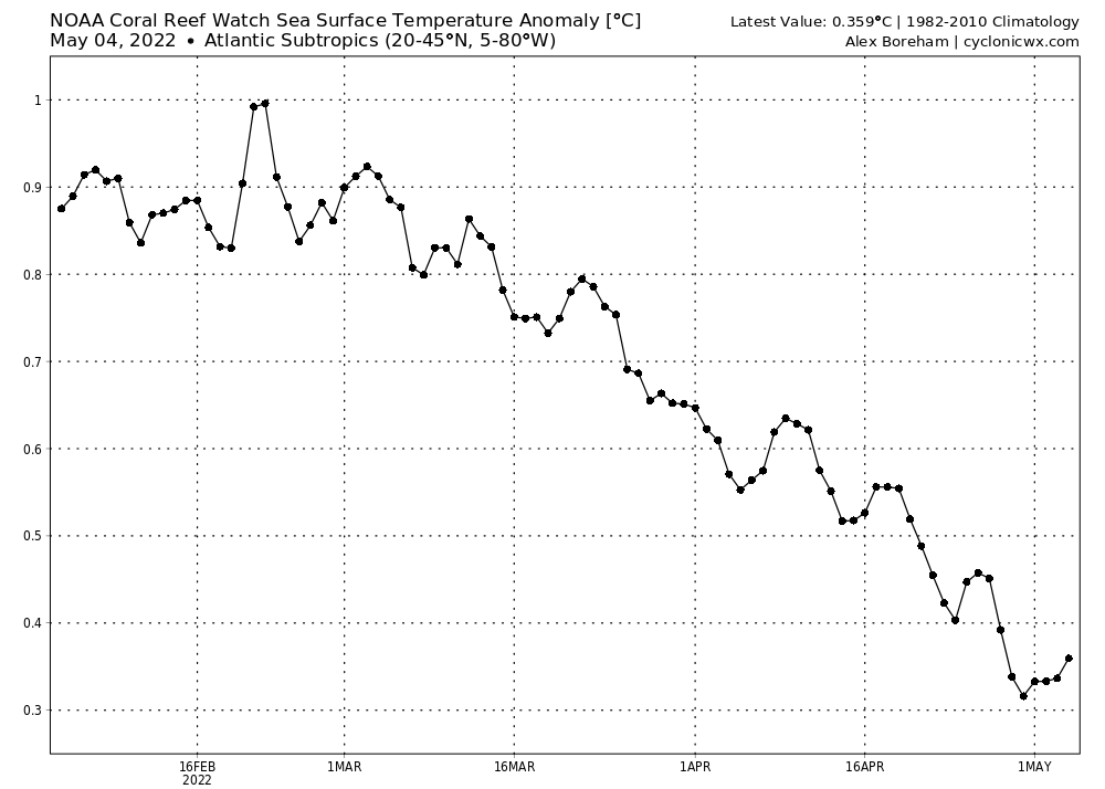
SST Anomaly Analysis for Atlantic Ocean MDR (Left) and subtropical Atlantic Ocean (Right)
ENSO Forecast
Seasonal modeling is in general agreement that La Niña or cool-neutral conditions will persist into the peak of hurricane season. There remains some disagreement between the ECMWF forecast and NCEP/NOAA regarding how much warming of ENSO occurs into summer, with the ECMWF taking ENSO into weak La Niña or cool-neutral, and the NCEP/NOAA modeling maintaining moderate La Niña through peak season. It’s important to note the ECMWF has a warm bias with ENSO that is magnified prior to the ENSO predictability barrier in May, as was the case in the lead-up to the last two hurricane seasons (2020-2021).
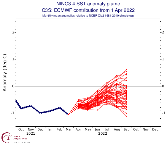
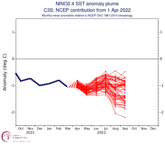
Sea surface temperature (SST) forecasts for NINO 3.4 from ECMWF (left) and NCEP (right) Source: Climate.copernicus.eu
The latest NOAA ENSO forecast agrees with latest modeling forecasts and has a ~50% likelihood La Niña persists into early-winter, with cool-neutral conditions being the second likeliest outcome. There’s a <10% chance El Niño conditions develop by mid-Winter. Given all known information, it’s expected cool-neutral or La Niña conditions will persist through hurricane season into early December. Overall, it’s unlikely ENSO will have an adverse impact on tropical cyclone development for the 2022 Hurricane Season.
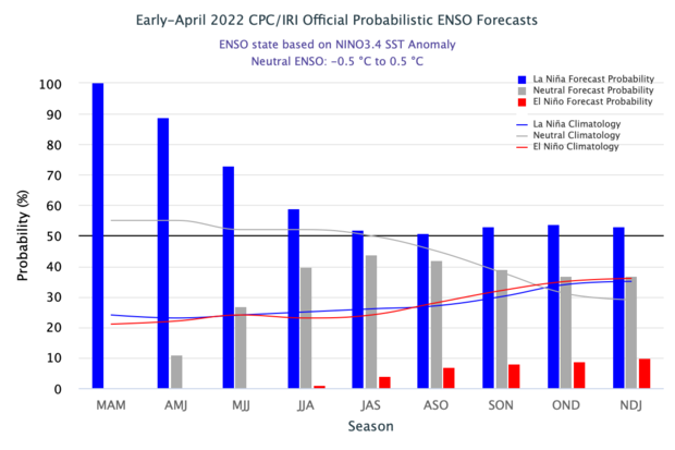
CPC/IRI Probabilistic ENSO Forecast from April Source: https://iri.columbia.edu/our-expertise/climate/forecasts/enso/current/
West-African Monsoon
The WAM is characterized by a reversal of the easterly trade winds to southwesterly and encroachment of the Inter-Tropical Convergence Zone (ITCZ) into west-central Africa during the warm season (June-September). The strength of the warm-season phase of the WAM is important for seasonal hurricane forecasting because it can influence sea surface temperatures within the Atlantic main development regions (MDR) off the Cape verde Islands. The WAM also determines the ‘dryness’ of the Sahel regions of Africa during summer, which can play a role in determining the strength of the Saharan Air Layer (SAL). During the most recent stretch of active hurricane seasons (2016-present), the West-African Monsoon has been stronger than normal, leading to anomalously warm SSTs in the MDR, larger than normal African Easterly Waves, and a reduction of SAL during peak season.
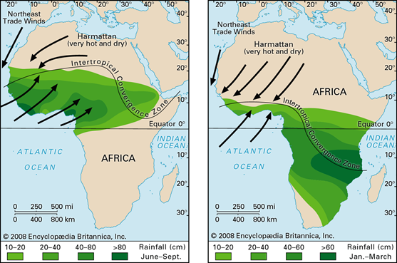
Diagram of the warm-season phase (left) and cold-season phase (right) of the West African Monsoon. Source: britannica.com SST Forecast
The C3S multi-system April seasonal forecast, which includes various model forecasts from around the world, shows a high likelihood of La Niña persisting through peak hurricane season. Additionally, this forecast favors near average SST anomalies in the Atlantic MDR, which is in-line with current conditions, hinting at the possibility the current warming trend in the MDR slows down as we head deeper into Spring. Lastly, this forecast shows the subtropical Atlantic warming back up by peak season. However, much uncertainty still exists in this forecast and the likely evolution of SSTs will remain ambiguous until later into Spring or early summer.
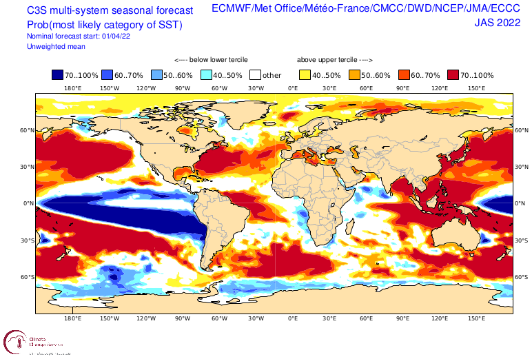
C3S Muti-system (ECMWF/UKMET/METEO France/CMC/NCEP/JMA/ECCC) April Probabilistic SST anomaly forecast for July-September. Source: https://climate.copernicus.eu/charts/c3s_seasonal/c3s_seasonal_spatial_mm_ssto_3m?facets=undefined&time=2022040100,2184,2022070100&type=tsum&area=area08
Accumulated Cyclone Energy (ACE)
Next, we’ll take a look at ACE forecasts from the ECMWF seasonal guidance. ACE is another way meteorologists assess how active a hurricane season will be. It is a metric that takes into account the strength and length of time of individual tropical cyclones during their lifetime. The latest ECMWF guidance is interestingly nearly identical to last year’s April ACE forecast for the 2021 season, indicating high chances that an above average ACE season will take place. However, given high uncertainty in this forecast, a slightly below-average hurricane season cannot be discounted.
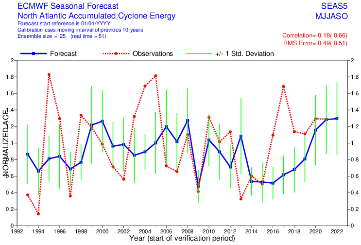
ECMWF May forecast of Normalized accumulated cyclone energy (ACE) based off historical averages, for the Atlantic Basin between April-November. (For example: ECMWF May forecast indicates 1.3 Normalized ACE, or 130% the long term average of 122.5 ACE units, Green lines represent +/- 1 standard deviations away from expected forecast, for the 2022 forecast the expected range of potential ACE outcomes is 0.9-1.75 Normalized ACE). Source: Climate.copernicus.eu
Analogs
Next we will examine hurricane season analogs, which can be used to assess seasons with similar initial conditions and comparative evolutions to what we expect for the upcoming hurricane season. The top four analogs we selected for this hurricane season include 2001, 2008, 2011, and 2021. These seasons saw an average of 18 named storms, 8 hurricanes, and 4 major hurricanes. They all featured La Niña or cool-neutral conditions present in spring, and remaining cold neutral through peak season. Some years selected also had a restrengthening of La Niña by mid-autumn, including 2008 and 2011. All analogs selected primarily had tropical activity during peak season confined to the Gulf of Mexico, MDR and subtropics, with 2001 and 2008 featuring late-season Caribbean activity due to the resurgence of La Niña.
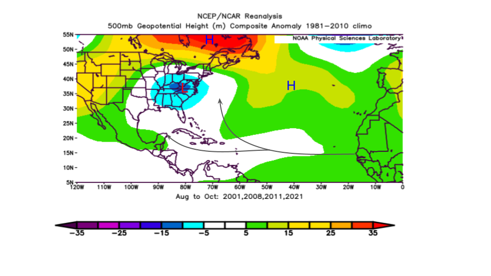
500mb Geopotential Anomalies for August-October in analog years (2001, 2008, 2011, 2021) using the NCEP-NCAR Reanalysis Source: psl.noaa.gov
The average upper-level steering pattern during peak season (August-October) during analog years featured a weakly defined upper trough over the Ohio Valley, with a large banana-shaped ridge over the top centered in Northern Quebec extending Southeastward and connecting with the Azores high across the subtropical North Atlantic. The presence of the Ohio Valley trough allowed most systems originating from the MDR to recurve prior to reaching the US East Coast or Caribbean.
Summary
Models are almost unanimous that La Niña or cool neutral ENSO conditions will persist through much of hurricane season. The current SST warming trend within the MDR is expected to continue through the next couple weeks. Thereafter, the forecast becomes increasingly uncertain. However, given most model forecasts show at least near-average SSTs during peak season, we expect SSTs in the MDR to not be a hindrance to tropical activity. Early-season activity in June-July will be focused in the Gulf of Mexico and off of the US East Coast, where tropical transitions over warmer than average SSTs will be possible. Subtropical SSTs across the North Atlantic have cooled over recent weeks. Despite this, most forecasts show warming resuming across the subtropics as spring begins to wane. Tropical activity across the subtropics may be above normal for the 2022 hurricane season, though may be less compared to recent seasons. The presence of La Niña may allow above normal late-season activity (October-November) as the Central American Gyre develops by Autumn. We expect to have an above-average hurricane season for 2022, with 20 named storms, 10 hurricanes, and 4 major hurricanes.
Watch this space for further updates.
Meanwhile stay connected and safe.