Meteorologists have traditionally analysed weather maps of upper air conditions using constant pressure surfaces as knowledge of what is happening aloft is needed to get an accurate picture overall since weather at the surface is influenced by conditions high up in the atmosphere. These weather maps or charts are prepared for several mandatory pressure levels from the temperature, humidity and wind data provided by observations. This data is provided from radiosondes supplemented by data from aircraft reports and satellite-derived wind data especially in data sparse regions such as remote oceans and the poles. The more common levels used are 250 hPa, 500 hPa, 700 hPa, 850 hPa, 925 hPa, and 1000 hPa.
Each level is typically used to learn something specific about the atmosphere. For instance, the 850 hPa (approx 5000 feet) level is above most of the influences of surface friction can be used to depict air masses, frontal boundaries and the type of precipitation, and the 500hPa (approx 18000 feet) level is usually considered to be the middle of the atmosphere where the trough (cold air) and ridge (warm air) patterns tend to become more evident. Further up the 300 hPA and 200 hPa levels provide a good idea of where the jet stream is located. In summer, the jet stream is closer to 200 hPa whereas, in winter, it is closer to the 300 hPa level. This blog will focus on the 500 hPa and 1000 hPa levels and how these help compile marine forecasts.
500 hPA level
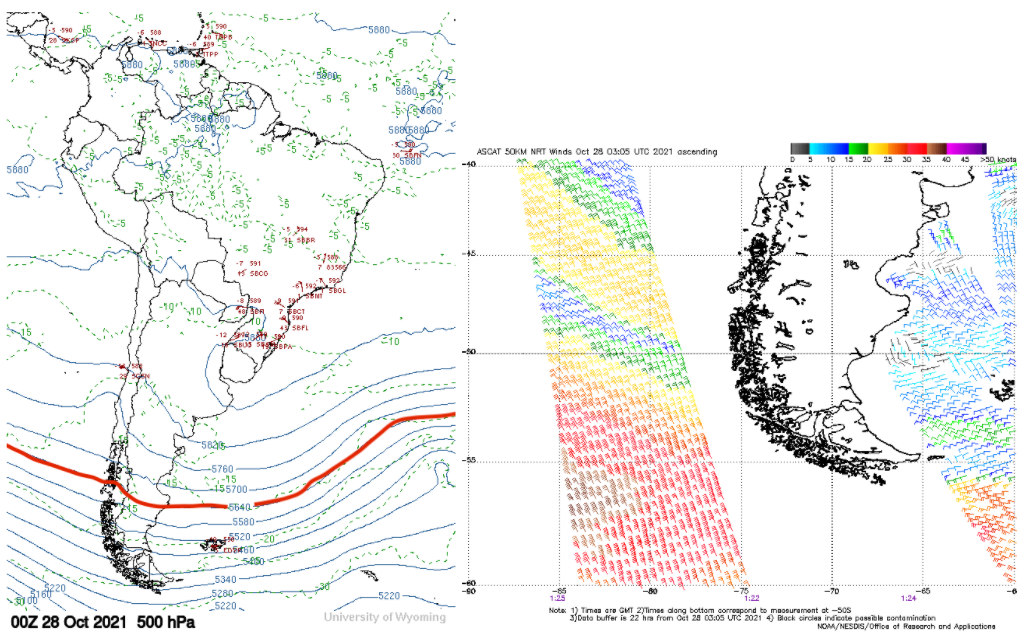
The 500 hPa chart is a constant pressure chart and the plotted contour lines represent the height in either meters or decameters that 500 hPa of air pressure is from the sea surface. If the chart shows three digit numbers then it shows decameters and if four digits then it is in meters. The 5640 meter line is a useful height line as two important weather features can be located near this height line. The first is the location of the storm track across the ocean which is usually within 300 to 600 nm poleward and tracks parallel to the height contour. It also marks the equatorward extent of where Beaufort Force 7 winds may occur during the winter and Beaufort Force winds 6 for the summer. More generally the speed that a surface low and associated fronts move at is 1/3 to ½ of the 500 hPa wind speed that is located above the surface low while the wind speed on the west to southwest side of a low pressure system is about 50% of the 500 hPa wind speed in cold air. Figure 1 shows this relationship between the 5640 meter line and surface winds near South America using Advanced Scatterometer data (ASCAT).

Figure 1: Relationship Between the 5640 Meter Line and Surface Winds observed by ASCAT. Source: University of Wyoming and NOAA NESDIS Office of Research and Applications
1000 hPa Level
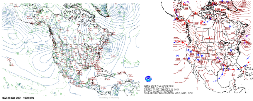
The 1000 hPa chart is commonly used to represent sea level. The depictions of pressure systems and fronts on this map represent the location of those features on the Earth’s surface. The actual 1000 hPa height can go below the Earth’s surface in some situations such as high terrain. A surface chart is very similar to the 1000 hPa chart, but the chart does not plot heights. Instead, surface pressure is plotted with areas of equal pressure connected with lines called isobars. In addition to isobars surface observations such as wind and temperature are plotted as well. Figure 2 shows the difference between the two types of charts. Further applications of pressure charts are discussed below.

Figure 2. Difference Between a 1000 hPa Chart (Left) and a Surface Analysis Chart (Right). Source: NOAA NCEP
During the winter cold air blowing over relatively warm water of a western boundary current like the Gulf Stream can result in what is known as the North Wall Effect. As the cold air moves over the relatively warm waters it de-stabilizes the boundary layer and this will allow strong winds to mix down to the surface. A surface chart is useful in this situation as the location of cold air can be inferred by the location of the cold front. The source of the cold air can be checked by reviewing the previous few days’ surface charts. If a cold front has passed recently over the location of the western boundary current a vessel can route on the cold-water side of the western boundary current to avoid the dangerous weather associated with a North Wall event. Figure 3 depicts typical North Wall effect scenarios for perpendicular and opposing wind flow directions off the NE USA. Similar occurrences occur off Japan and in the southern hemisphere, particularly in the infamous Agulhas current off South Africa.

Figure 3. North Wall effect scenarios for perpendicular and opposing wind flow directions off NE USA. Source: NOAA NCEP
Another major hazard to vessels in winter is freezing spray. Freezing spray results in ice buildup on a vessel which increases the topside weight of the vessel with the risk of capsizing during heavy weather. An example of this risk was the sinking of the F/V Scandies Rose on 31 December 2019 with the loss of five crew members as the result of asymmetric ice buildup on the vessel and inaccurate instructions on how to calculate the vessel’s stability. Freezing spray is a possibility when winds are Beaufort Force 6 or greater, sea surface temperature (SST) is less than 4C, and air temperature is less than 0 to -1C. It is possible for freezing spray to occur when the SST is greater than 4C when winds are extremely cold. The areas of Beaufort Force 6 or greater can be inferred from a surface chart by looking for areas where isobars are tightly packed and can be directly located if there is a surface observation nearby.
Summary
Pressure charts are a very useful way to see weather features at different levels with the 500 hPa and 1000 hPa charts being very useful for Mariners. The 500 hPa chart on its own can give the approximate location of the storm track, the equatorward extent of strong to near gale winds depending on the season, and the speed of low-pressure systems. The 1000 hPa and surface chart shows the location of weather systems on the surface and the relative wind speed inferred by the spacing of isobars on the surface chart. These charts when combined with knowledge of other weather parameters can be used to locate areas that are conducive to a north wall event and freezing spray.
Stay safe and connected.