Looking back at 2024, we analyse the Atlantic Hurricane Season which concluded on November 30th. With the National Oceanic and Atmospheric Administration (NOAA) having released their final seasonal update, we can now examine the final numbers and key highlights from this notable season.
May: NOAA’s Initial 2024 Atlantic Hurricane Season Outlook
In May 2024, meteorologists and forecasters at the Climate Prediction Center, an agency that is part of NOAA, released their 2024 Atlantic Hurricane Season Outlook. In this initial outlook and seasonal forecast, NOAA predicted an 85% chance that the hurricane season, lasting from June 1st to November 30th, would be an above normal season, with a 10% chance of the season being near normal and a 5% chance of being below normal.
For reference, a normal (or “average”) hurricane season for the Atlantic Ocean consists of fourteen named tropical cyclones. In order for a tropical cyclone to be named in the Atlantic Ocean, the system must have a one-minute sustained wind speed of 34 knots or greater. Of those fourteen named tropical systems, seven of them on average are expected to reach hurricane intensity, having one-minute sustained wind speeds of 64 knots or higher. Lastly, of those seven hurricanes, three of them on average reach major hurricane status, with one-minute sustained wind speeds of 96 knots or more.
Alongside NOAA’s chances for the hurricane season to be above, below, or near normal, forecasters predicted 17-25 named tropical systems, with 8-13 of those systems expected to reach hurricane intensity, and 4-7 of those hurricanes expected to be classified as major hurricanes. This seasonal forecast had a confidence level of 70%.
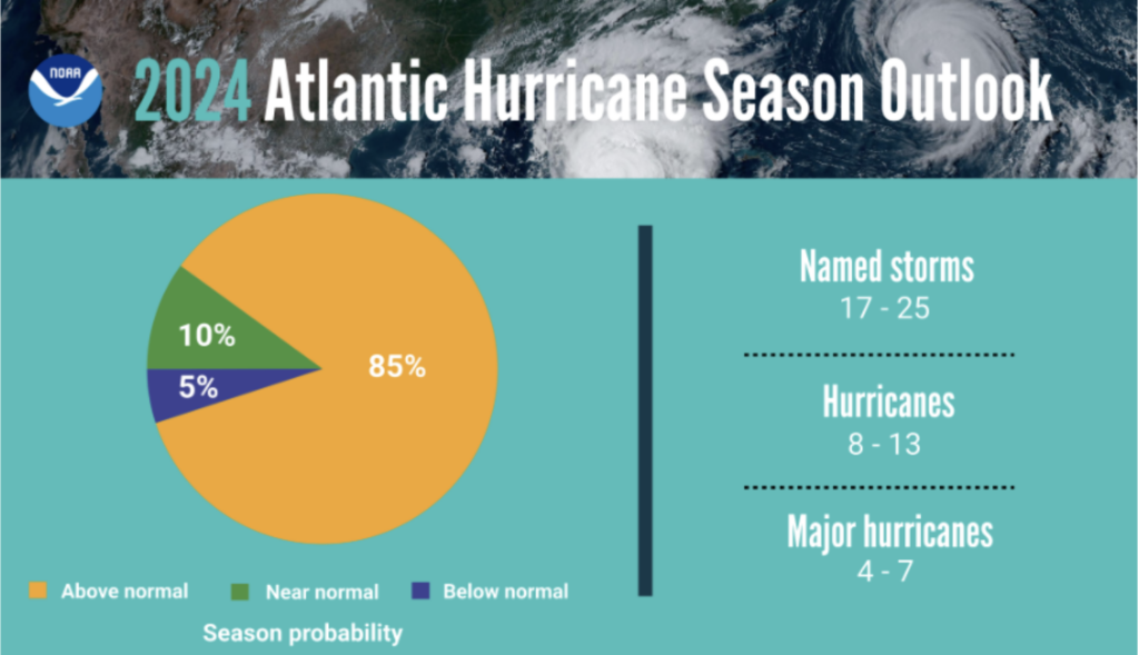
Fig 1: Summary of NOAA’s 2024 Atlantic Hurricane Season Outlook from May 2024.
Confidence in this pre-season outlook, as well as for the derived numbers of the forecast itself, were primarily based on two major factors. First, forecasters predicted near-record breaking warm sea surface temperatures in the tropical North Atlantic Ocean, with sea surface temperatures expected to be well above 26°C (78.8°F). Second, climatologists predicted the transition from El Niño to La Niña to occur during hurricane season.
Despite occurring in the Pacific Ocean, through teleconnections (a “ripple effect” in the atmosphere) a La Niña pattern is more favorable for tropical cyclone development in the tropical Atlantic Ocean due to the pattern resulting in less vertical wind shear in the basin.
NOAA indicated that their outlook and seasonal forecast took into account other factors as well, specifically weaker than normal trade winds in the tropical North Atlantic Ocean and an above normal West African Monsoon.
Pole Star’s Preliminary 2024 Atlantic Hurricane Season Forecast
Our own prediction and forecast for the 2024 Atlantic Hurricane Season, made on April 19th-20th, 2024 and released about three weeks before NOAA released their outlook on May 3rd, had also called for an above average hurricane season. Specifically, Pole Star’s forecast for the season predicted 24 named tropical systems, 8 of which would reach hurricane intensity, and 5 of which would become major hurricanes.
We cited several major environmental factors for predicting such an aggressive, above average hurricane season. Our first major reason was the above average sea surface temperatures, already 1-2°C above average as of mid-April 2024. We had ample reason to believe that those same above average sea surface temperatures would persist until the end of November. Our second major reason was the expectation of a moderate to strong La Niña developing during hurricane season sometime in the mid to late summer.
Other reasons were also noted and cited in Fleetweather’s outlook, including abnormally high moisture content across the Caribbean Sea and the Gulf of Mexico and Colorado State’s Tropical Outlook forecasting the Accumulated Cyclone Energy (ACE) value for the Atlantic basin to be 210 (average ACE for the Atlantic is typically 66-103). Only factor that we cited as possibly having a detrimental impact to the upcoming hurricane season was the presence of Saharan dust aloft in the atmosphere over the tropical North Atlantic Ocean.
The August Update: More of the Same
Every year, once mid way through the Atlantic hurricane season, NOAA will release an updated seasonal forecast and outlook. In this update, the forecasters take into account the systems that have already occurred as well as how, if at all, the environmental conditions changed over the previous two months or how they are expected to change going forwards.
In the 2024 Atlantic Hurricane Mid-Season Update, released only a few weeks before the climatological peak of hurricane season, only minor changes were made to NOAA’s initial prediction from May.
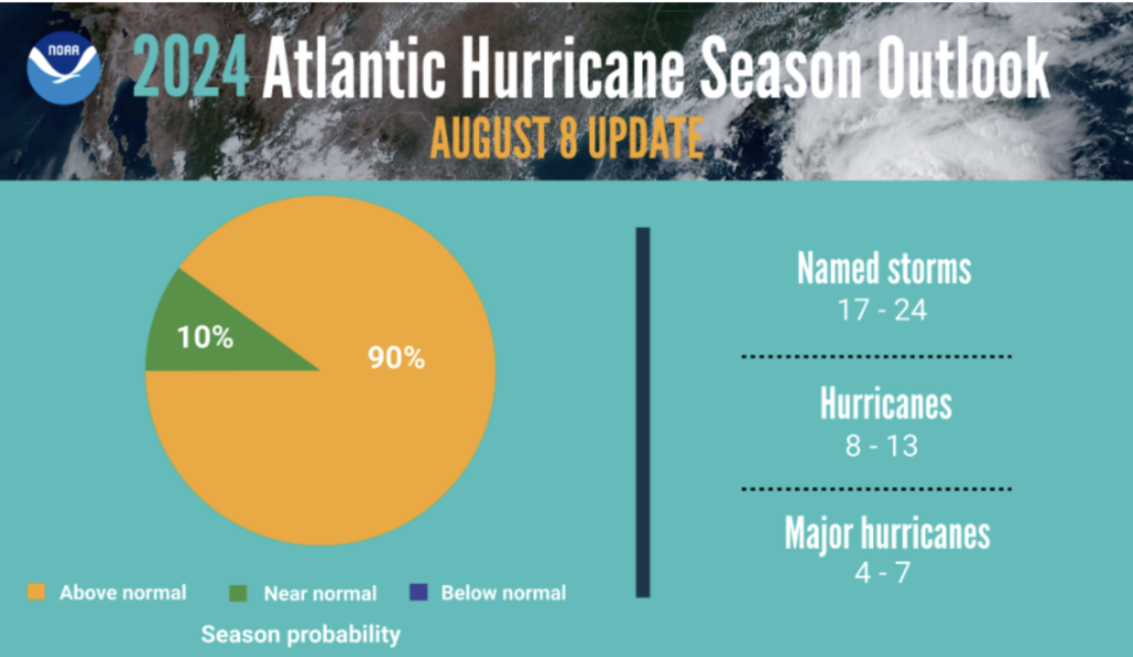
Fig 2: Summary of NOAA’s 2024 Atlantic Hurricane Mid-Season Update from August 2024.
This updated forecast was still based on the same two major factors as the initial season forecast from May: sea surface temperatures remaining abnormally high and the El Niño Southern Oscillation (ENSO) switching to La Niña sometime in the second half of hurricane season. Other factors cited by the forecasters from NOAA include weaker than normal trade winds in the tropical North Atlantic Ocean, an enhanced west African Monsoon, and the warm phase on the Atlantic Multi-Decadal Oscillation.
NOAA also forecasted the Saharan air aloft in the atmosphere over the tropical North Atlantic Ocean to subside before the end of August. This dry and dusty air mass was cited by NOAA as the reason there was reduced tropical cyclone activity during the middle of the summer.
The November Update: A Preliminary Seasonal Overview
Towards the end of November, at the tail end of hurricane season in the Atlantic Ocean, the forecasters at NOAA give one last update: the 2024 Atlantic Hurricane End of Season Update. However, this update is more of a quick summary and number count of all the tropical systems that had occurred in the last almost six months.
In this final seasonal update, NOAA gave us the final tally: 18 named tropical systems, with 11 of those systems reaching hurricane intensity, 5 of them reached major hurricane status. With these final numbers, it is clear that the 2024 Atlantic Hurricane Season fell within NOAA’s initial busy, above average prediction for the season in May, as well as their updated prediction in August.
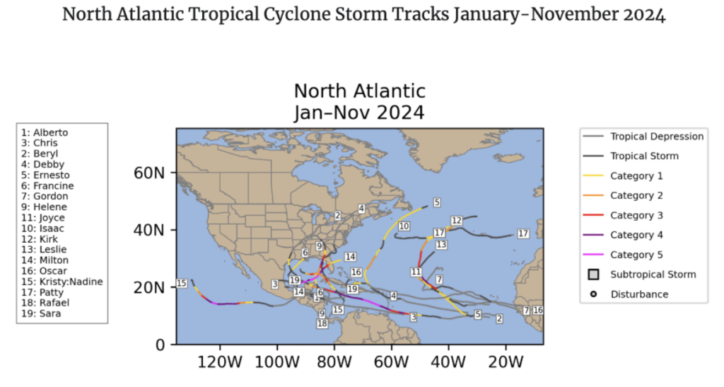
Fig 3: Complete Forecast Track and Intensity Summary of all named tropical systems in the Atlantic Ocean, 2024. Source
Notable statistics emerged from this final update: of the 18 total named tropical cyclones, 12 developed after the season’s climatological peak (early to mid-September), meaning two-thirds of all tropical cyclone activity occurred in the second half of the season. Additionally, 7 hurricanes formed between September 25th and the end of November, the most hurricanes on record for this time period.
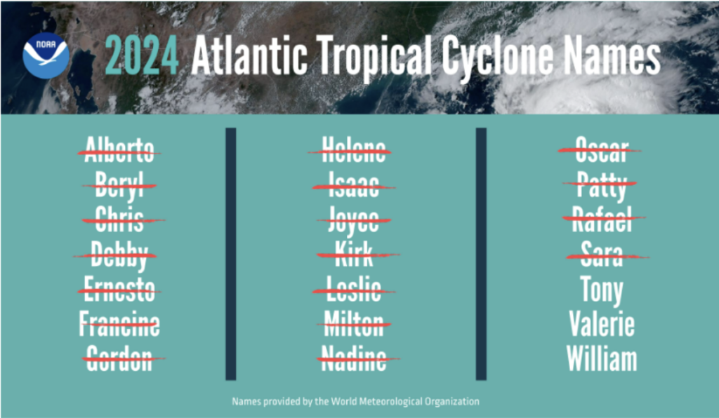
Fig 4: The 2024 Atlantic Hurricane Season naming list with used names marked.
A Year to Remember: Highlights, Records, and Notable Names
The data mentioned by NOAA in their end of the season update were, unfortunately, not the only important notes to come out of this hurricane season. A few record-setting hurricanes are discussed below.
Hurricane Helene, which formed September 24th and dissipated September 29th, became the first system that the National Hurricane Center (NHC) forecasted to reach major hurricane status before being classified as a tropical depression or tropical storm. Helene received widespread international media attention due to the unprecedented path of destruction across the southeastern United States.
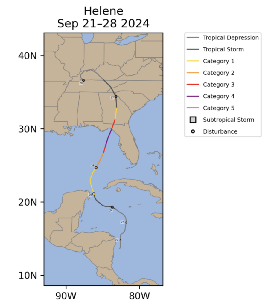
Fig 5: Complete Forecast Track and Intensity Summary of Hurricane Helene, September 2024. Source
Hurricane Milton, which formed October 5th and dissipated October 13th, demonstrated one of the highest rates of rapid intensification ever recorded, with measured sustained wind speeds increasing by 78 knots in 24 hours during October 6th-7th.
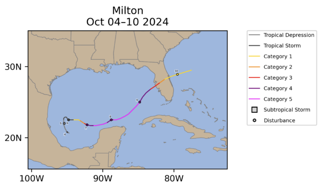
Fig 6: Complete Forecast Track and Intensity Summary of Hurricane Milton, October 2024. Source
Pole Star’s Initial Prediction in Hindsight
Comparing the final numbers with our initial forecast reveals our initial prediction for 24 named tropical systems was higher than the reality: 18 named tropical systems occurred. On the flip side, our prediction for 8 of those systems to become hurricanes was lower than reality: 11 hurricanes. Lastly, our forecast for there to be 5 major hurricanes this year was right on target!
Our initial reasoning was very close to NOAA’s and why they believed the season would be above normal in their initial outlook. Indeed, abnormally high sea surface temperatures and lower than normal wind shear in the tropical Atlantic Ocean played major roles in making this hurricane season very active and above average. Our prediction of the Saharan Dust Layer over the tropical North Atlantic Ocean inhibiting tropical cyclone formation and development also held substantial weight until late summer.
Alongside the Saharan Dust Layer, which resulted in an increase in dry air advection and above normal warm temperatures aloft in the atmosphere, there were other factors that contributed to the lull in tropical activity during the late summer, specifically from late August to mid September. Per Colorado State’s Mid-Season Tropics Discussion, a northwards shift in the easterly waves coming off of Africa, an increase in vertical wind shear in the eastern and central tropical Atlantic Ocean, and the phases of the Madden-Julien Oscillation (MJO) being unfavourable for tropical cyclone formation all contributed to the sharp decrease in tropical cyclone activity during this time period, right when tropical cyclone activity climatologically hits its peak and is at its highest.
Also of note, the transition to La Niña in the Pacific Ocean seems to have occurred much more gradually than anyone initially expected.
Wrapping up 2024 Atlantic Hurricane Season
The 2024 Atlantic Hurricane Season had some people and agencies sounding the alarm due to the rising concern of climate change, and then further alarmed once the status (and predicted change) of ENSO became more clear. But it’s all over and done with for now, with the coastlines and the waters of the tropical Atlantic Ocean now safe from tropical systems for the next half year or so.
Notably, it is yet to be seen if the National Hurricane Center will retire any of the tropical cyclone names that were used this year, with the NHC’s post-hurricane season analysis and discussion planned to happen within the next few months, we may get our answer to that question soon enough.
The Pole Star team continues to monitor weather patterns worldwide, providing safe and efficient weather routing to vessels. Please reach out to our team of accredited marine routers at any time to activate Pole Star’s weather routing and forecast services. Pole Star Global remains committed to providing optimum guidance to your vessels for any future tropical cyclones or heavy weather that threatens their voyage.
Stay connected and safe, and watch for our 2025 pre-season Atlantic tropical outlook in April 2025.